IMAGES TAKEN NEAR TO
Fourth Avenue, DONCASTER, DN6 7QB
Introduction
This page details the photographs taken nearby to Fourth Avenue, DN6 7QB by members of the Geograph project.
The Geograph project started in 2005 with the aim of publishing, organising and preserving representative images for every square kilometre of Great Britain, Ireland and the Isle of Man.

There are currently over 7.5m images from over14,400 individuals and you can help contribute to the project by visiting https://www.geograph.org.uk
Image Map
Images are licensed for reuse under creativecommons.org/licenses/by-sa/2.0
Notes
- Clicking on the map will re-center to the selected point.
- The higher the marker number, the further away the image location is from the centre of the postcode.
Image Listing (6 Images Found)
Images are licensed for reuse under creativecommons.org/licenses/by-sa/2.0
Image
Details
Distance
1
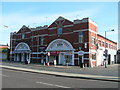
Woodlands, Doncaster
Brodsworth Miners Welfare Institute. Built 1924.
http://flickr.com/photos/riffraff1/3016684716/
Image: © David Hebb
Taken: 13 Dec 2008
0.05 miles
2

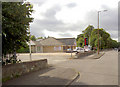
A638 Road in Adwick Le Street
Dual carriageway (and Great North Road) pictured here looking across towards a sports field.
Image: © Jonathan Clitheroe
Taken: 28 Nov 2016
0.13 miles
3
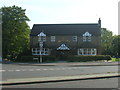
Aagrah Indian restaurant.
Part of a chain based in Shipley.
Image: © Steve Fareham
Taken: 31 Aug 2007
0.16 miles
4
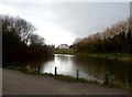
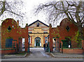
Cross-Grid View in Highfields Country Park
Looking across a lake towards Highfields Social Club.
Image: © Jonathan Clitheroe
Taken: 6 Mar 2017
0.18 miles