IMAGES TAKEN NEAR TO
Ridge Balk Lane, DONCASTER, DN6 7NP
Introduction
This page details the photographs taken nearby to Ridge Balk Lane, DN6 7NP by members of the Geograph project.
The Geograph project started in 2005 with the aim of publishing, organising and preserving representative images for every square kilometre of Great Britain, Ireland and the Isle of Man.

There are currently over 7.5m images from over14,400 individuals and you can help contribute to the project by visiting https://www.geograph.org.uk
Image Map
Images are licensed for reuse under creativecommons.org/licenses/by-sa/2.0
Notes
- Clicking on the map will re-center to the selected point.
- The higher the marker number, the further away the image location is from the centre of the postcode.
Image Listing (18 Images Found)
Images are licensed for reuse under creativecommons.org/licenses/by-sa/2.0
Image
Details
Distance
1
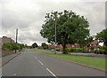
Ridge Balk Lane
Leaving the A638 towards Brodsworth.
Image: © Steve Fareham
Taken: 8 Jul 2008
0.03 miles
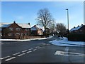
2
Osborne Avenue, Adwick le Street
Part of a fan-shaped estate at the north-west corner of the village.
Image: © Christine Johnstone
Taken: 2 Feb 2019
0.10 miles
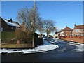
3
Junction of Osborne and Shaftesbury Avenues
Part of a fan-shaped estate at the north-west corner of Adwick le Street.
Image: © Christine Johnstone
Taken: 2 Feb 2019
0.11 miles
4
Fairview Avenue, Adwick le Street
Part of a fan-shaped estate at the north-west corner of the village.
Image: © Christine Johnstone
Taken: 2 Feb 2019
0.12 miles
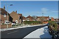
5
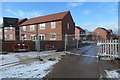
Woodland Ridge, off Ridge Balk Lane
'A select development of detached and semi-detached homes' on the western edge of Adwick le Street.
Image: © Christine Johnstone
Taken: 2 Feb 2019
0.18 miles
6
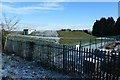
Covered reservoir, Adwick le Street
Off Fairview Avenue. The snow has melted on the south side.
Image: © Christine Johnstone
Taken: 2 Feb 2019
0.19 miles
7

Old Milestone, A638, Adwick between Tenter Balk Lane & Windmill Balk Lane
Located on the East side of road, down banking, north side of Electrical Substation in front of school. Stone post (plate lost), Brayshaw & Booth casting design, 19th century.
Inscription reads: (DONCASTER / 4 MILES) // (YORK / 32¾ MILES / TADCASTER / 23¼ MILES / WAKEFIELD / 16 MILES / LEEDS / 23½ MILES / PONTEFRACT / 10¼ MILES) // TADCASTER & DONCASTER / ROAD / ADWICK / LE / STREET // (BRAYSHAW & BOOTH / MAKERS / LIVERSEDGE)
Milestone Society National ID: YS_DNTC04
Image: © Christine Minto
Taken: 28 Jan 2021
0.20 miles
8

Old milestone
Since the last photograph of this West Riding CC milestone which has lost its metal attachment, a new school has been built on the fields over the fence. It is near an Electricity sub-station. The left face had DONCASTER/4 MILES, the right face YORK/32¾ MILES/TADCASTER/23½ MILES/WAKEFIELD/16 MILES/LEEDS/23½ MILES/PONTEFRACT/10¼ MILES. TADCASTER & DONCASTER/ROAD/ADWICK/LE/STREET was on the top section. The foundry name Brayshaw & Booth of Liversedge would have been on the bevel. The place names were set at an angle to fit in the longest name, Pontefract.
Image: © Chris Minto
Taken: 19 Jan 2022
0.20 miles
9
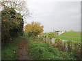
Roman Ridge at Adwick
Service reservoir to the right
Image: © John Slater
Taken: 30 Oct 2014
0.21 miles
10
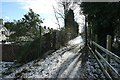
Roman Ridge, alongside houses in West Avenue
A path on the route of the Roman road heading north out of Doncaster.
Image: © Christine Johnstone
Taken: 2 Feb 2019
0.21 miles