IMAGES TAKEN NEAR TO
Windmill Balk Lane, DONCASTER, DN6 7LF
Introduction
This page details the photographs taken nearby to Windmill Balk Lane, DN6 7LF by members of the Geograph project.
The Geograph project started in 2005 with the aim of publishing, organising and preserving representative images for every square kilometre of Great Britain, Ireland and the Isle of Man.

There are currently over 7.5m images from over14,400 individuals and you can help contribute to the project by visiting https://www.geograph.org.uk
Image Map
Images are licensed for reuse under creativecommons.org/licenses/by-sa/2.0
Notes
- Clicking on the map will re-center to the selected point.
- The higher the marker number, the further away the image location is from the centre of the postcode.
Image Listing (25 Images Found)
Images are licensed for reuse under creativecommons.org/licenses/by-sa/2.0
Image
Details
Distance
1
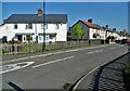
Grosvenor Road, Woodlands, Adwick-le-Street
Image: © Neil Theasby
Taken: 21 Apr 2022
0.03 miles
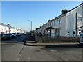
2

Junction of Grosvenor Road and Windmill Balk Lane
In the Woodlands area of Adwick le Street.
Image: © Christine Johnstone
Taken: 15 Feb 2019
0.03 miles
3

Trees on the north side of Windmill Balk Lane
In the Woodlands area of Adwick le Street.
Image: © Christine Johnstone
Taken: 15 Feb 2019
0.06 miles
4

Football pitches, The Park, Adwick le Street
On the north side of Windmill Balk Lane.
Image: © Christine Johnstone
Taken: 15 Feb 2019
0.09 miles
5
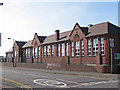
Adwick - Primary School
Caxton Road frontage.
Image: © Dave Bevis
Taken: 16 Apr 2014
0.10 miles
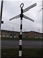
6
Direction Sign – Signpost on Doncaster Lane, Adwick le Street
Located on an island on the southeast side of the junction of the B1220 Doncaster Lane and Windmill Balk Lane at Adwick le Street, in Doncaster metropolitan district. 3 arms and annulus finial. A replacement for https://www.geograph.org.uk/photo/6546354 some time after January 2021.
Milestone Society National ID: YW_SE5408
Image: © N Upton
Taken: 1 Aug 2023
0.10 miles
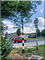
7
Direction Sign – Signpost on Doncaster Lane, Adwick le Street
Located on an island on the southeast side of the junction of the B1220 Doncaster Lane and Windmill Balk Lane at Adwick le Street, in Doncaster metropolitan district. 3 arms and annulus finial. Replaced at a slightly different location after roadworks some time between January 2021 and August 2023, see https://www.geograph.org.uk/photo/7589667,
Milestone Society National ID: YW_SE5408
Image: © C Minto
Taken: 5 Jan 2019
0.10 miles
8

House converted into offices, Doncaster Lane, Adwick le Street
Used by St Leger Homes.This company manages Doncaster Council's 21,000 homes and is wholly owned by the council.
Image: © Christine Johnstone
Taken: 15 Feb 2019
0.14 miles
9

Entrance to Outwood Academy, Windmill Balk Lane, Adwick
This school has had several identities - Percy Jackson Grammar School, a comprehensive from 1968, then specialist status as North Doncaster Technology College. In 2009 the school converted to academy status and was renamed Outwood Academy Adwick. The Outwood Grange Academy Trust's Multi-Academy Trust [OGAT MAT] runs 21 academies, one junior academy and nine primary academies.
Image: © Christine Johnstone
Taken: 15 Feb 2019
0.15 miles
10
Houses east of Villa Road, Woodlands
On the south side of Woodlands Road.
Image: © Christine Johnstone
Taken: 15 Feb 2019
0.18 miles