IMAGES TAKEN NEAR TO
Woodside Road, DONCASTER, DN6 7JR
Introduction
This page details the photographs taken nearby to Woodside Road, DN6 7JR by members of the Geograph project.
The Geograph project started in 2005 with the aim of publishing, organising and preserving representative images for every square kilometre of Great Britain, Ireland and the Isle of Man.

There are currently over 7.5m images from over14,400 individuals and you can help contribute to the project by visiting https://www.geograph.org.uk
Image Map
Images are licensed for reuse under creativecommons.org/licenses/by-sa/2.0
Notes
- Clicking on the map will re-center to the selected point.
- The higher the marker number, the further away the image location is from the centre of the postcode.
Image Listing (27 Images Found)
Images are licensed for reuse under creativecommons.org/licenses/by-sa/2.0
Image
Details
Distance
3
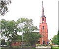
Adwick - All Saints Church
For more information about this church, please see http://www.all-saints-church.net/about-us/church-history/ .
Image: © Dave Bevis
Taken: 16 Apr 2014
0.07 miles
4
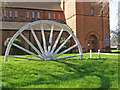
Adwick - mining memorial at All Saints Church
This is a memorial to Brodsworth Colliery, which was situated about half a mile to the west of All Saints Church. The colliery was opened in 1905 and closed in 1990. See also http://en.wikipedia.org/wiki/Brodsworth_Colliery .
Image: © Dave Bevis
Taken: 16 Apr 2014
0.08 miles
5
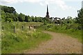
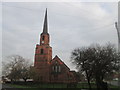
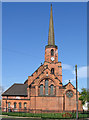
All Saints, Woodlands
The spire of this church seems to pop up on the horizon all around these parts.
Image: © John Bayes
Taken: 30 May 2009
0.09 miles
7
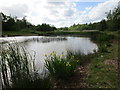
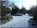
Roman Ridge heading south by Beck Hill Plantation
The route of the Roman road running north from Doncaster.
Image: © Christine Johnstone
Taken: 2 Feb 2019
0.10 miles
8
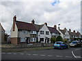
Houses on Quarry Lane
Part of the Woodlands model village created for the workers at Brodsworth Colliery. Many of the houses are listed (such as the block of three closest to the camera) http://www.britishlistedbuildings.co.uk/en-334885-17-19-quarry-lane-#.VWt1IkbocnA
Image: © Jonathan Thacker
Taken: 31 May 2015
0.10 miles
9
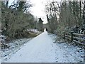
Footpath junction on Roman Ridge
Roman Ridge is the route of the Roman road running north from Doncaster.
Image: © Christine Johnstone
Taken: 2 Feb 2019
0.11 miles
10
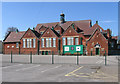
Adwick - Woodlands Primary School
Playground and rear of the west block.
Image: © Dave Bevis
Taken: 16 Apr 2014
0.11 miles