IMAGES TAKEN NEAR TO
Ridge Road, DONCASTER, DN6 7JF
Introduction
This page details the photographs taken nearby to Ridge Road, DN6 7JF by members of the Geograph project.
The Geograph project started in 2005 with the aim of publishing, organising and preserving representative images for every square kilometre of Great Britain, Ireland and the Isle of Man.

There are currently over 7.5m images from over14,400 individuals and you can help contribute to the project by visiting https://www.geograph.org.uk
Image Map
Images are licensed for reuse under creativecommons.org/licenses/by-sa/2.0
Notes
- Clicking on the map will re-center to the selected point.
- The higher the marker number, the further away the image location is from the centre of the postcode.
Image Listing (10 Images Found)
Images are licensed for reuse under creativecommons.org/licenses/by-sa/2.0
Image
Details
Distance
1

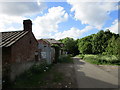
Tithe Barn on Roman Ridge Byway
Despite its poor state this is clearly a building of some antiquity as evidenced by the haphazard quoin stones and rubble walls.
Image: © Jonathan Clitheroe
Taken: 6 Mar 2017
0.05 miles
2
Buildings at Tithe Barn
Presumably the Tithe Barn is the taller stone built and slate roofed building farthest away from the camera.
Image: © Jonathan Thacker
Taken: 31 May 2015
0.05 miles
3
A collection of barns.
In late afternoon winter sun.
Image: © steven ruffles
Taken: 1 Feb 2010
0.05 miles
4
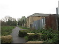
Buildings at Tithe Barn
The track is Roman Ridge
Image: © John Slater
Taken: 30 Oct 2014
0.06 miles
5
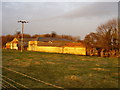
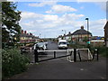
South Street, Highfields, from Roman Ridge
With a 43 metre spot height at the road junction. This village was built to house mining families.
Image: © Christine Johnstone
Taken: 2 Feb 2019
0.09 miles
6
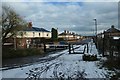
South Street, Highfields
The houses at this end of Highfields are unusual for that settlement in that they face the street whereas most turn their backs to the street to face on to open spaces.
Image: © Jonathan Thacker
Taken: 31 May 2015
0.09 miles
7
Fly-tipped rubbish in Hanging Woods
Part of Highfields Country Park, alongside Roman Ridge byway.
Image: © Christine Johnstone
Taken: 2 Feb 2019
0.14 miles
8
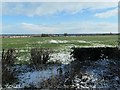
Highfields Viewed from Roman Ridge
Image: © Jonathan Clitheroe
Taken: 6 Mar 2017
0.17 miles
9
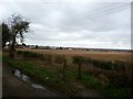
Highfields farmland, east of Roman Ridge
The area is called Highfields, the farm High Fields. The land is about 40 metres above sea level.
Image: © Christine Johnstone
Taken: 2 Feb 2019
0.19 miles
10
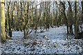
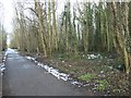
Hanging Wood, Highfields Country Park
Looking east from Roman Ridge.
Image: © Christine Johnstone
Taken: 2 Feb 2019
0.23 miles