IMAGES TAKEN NEAR TO
Swift Close, DN6 7FT
Introduction
This page details the photographs taken nearby to Swift Close, DN6 7FT by members of the Geograph project.
The Geograph project started in 2005 with the aim of publishing, organising and preserving representative images for every square kilometre of Great Britain, Ireland and the Isle of Man.

There are currently over 7.5m images from over14,400 individuals and you can help contribute to the project by visiting https://www.geograph.org.uk
Image Map
Images are licensed for reuse under creativecommons.org/licenses/by-sa/2.0
Notes
- Clicking on the map will re-center to the selected point.
- The higher the marker number, the further away the image location is from the centre of the postcode.
Image Listing (23 Images Found)
Images are licensed for reuse under creativecommons.org/licenses/by-sa/2.0
Image
Details
Distance
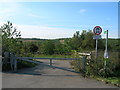
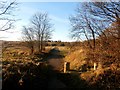
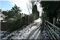
1

Footpath junction on Roman Ridge
On the right, the route of the Roman road heading north from Doncaster [Roman ridge]. On the left, a public footpath to Woodlands on a former colliery site.
Image: © Christine Johnstone
Taken: 2 Feb 2019
0.08 miles
3
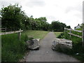
The Roman Ridge at Woodlands
Signposted as a byway but clearly not open to four wheeled traffic.
Image: © Jonathan Thacker
Taken: 31 May 2015
0.10 miles
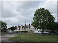
5
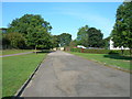
The Crescent, Woodlands
Woodlands is a model village north of Doncaster. It was designed and built in the early 1900s by the architect Percy Houfton as tied cottages for the families of miners working at the nearby Brodsworth Colliery. It has many different types of houses, set out among large open spaces, and is now a conservation area.
Image: © Christine Johnstone
Taken: 2 Feb 2019
0.12 miles
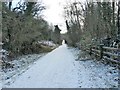
6
Footpath Fringing Brodsworth Community Woodland
Image: © Jonathan Clitheroe
Taken: 28 Nov 2016
0.12 miles
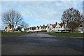
7
Houses on the Crescent, Woodlands
Woodlands is a model village built for the workers at Brodsworth Colliery. It has many similarities to places such as Letchworth or Welwyn Garden City but is much less well known. http://en.wikipedia.org/wiki/Woodlands,_South_Yorkshire
Image: © Jonathan Thacker
Taken: 31 May 2015
0.14 miles
8
Roman Ridge heading south by Beck Hill Plantation
The route of the Roman road running north from Doncaster.
Image: © Christine Johnstone
Taken: 2 Feb 2019
0.15 miles
9
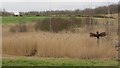
Brodsworth Community Woodland
Restored colliery slags heaps
Image: © James Wood
Taken: 15 Mar 2015
0.15 miles
10
Roman Ridge, alongside houses in West Avenue
A path on the route of the Roman road heading north out of Doncaster.
Image: © Christine Johnstone
Taken: 2 Feb 2019
0.17 miles