IMAGES TAKEN NEAR TO
DN6 7AJ
Introduction
This page details the photographs taken nearby to DN6 7AJ by members of the Geograph project.
The Geograph project started in 2005 with the aim of publishing, organising and preserving representative images for every square kilometre of Great Britain, Ireland and the Isle of Man.

There are currently over 7.5m images from over14,400 individuals and you can help contribute to the project by visiting https://www.geograph.org.uk
Image Map
Images are licensed for reuse under creativecommons.org/licenses/by-sa/2.0
Notes
- Clicking on the map will re-center to the selected point.
- The higher the marker number, the further away the image location is from the centre of the postcode.
Image Listing (10 Images Found)
Images are licensed for reuse under creativecommons.org/licenses/by-sa/2.0
Image
Details
Distance
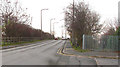
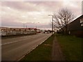
3
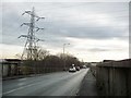
Station Road, Carcroft Common
The B1220, heading south.
Image: © Christine Johnstone
Taken: 20 Dec 2017
0.11 miles
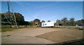
4
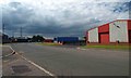
Industrial estate, Carcroft Common
Depots and factories off Brooklands Road.
Image: © Christine Johnstone
Taken: 20 Dec 2017
0.13 miles
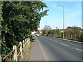
5
The Railway Bridge between Carcroft and Carcroft Common.
Image: © Bill Henderson
Taken: 30 Nov 2006
0.13 miles
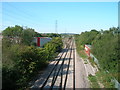
9
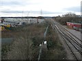
Railway heading west from Carcroft Common
To join the ECML at north and south facing junctions [Adwick and Carcroft].
Image: © Christine Johnstone
Taken: 20 Dec 2017
0.19 miles
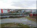
10
Bentley Moor Lane
Industrial area at Carcoft Common
Image: © Jonathan Clitheroe
Taken: 9 Jan 2016
0.23 miles