IMAGES TAKEN NEAR TO
Lawn Lane, DONCASTER, DN6 0HB
Introduction
This page details the photographs taken nearby to Lawn Lane, DN6 0HB by members of the Geograph project.
The Geograph project started in 2005 with the aim of publishing, organising and preserving representative images for every square kilometre of Great Britain, Ireland and the Isle of Man.

There are currently over 7.5m images from over14,400 individuals and you can help contribute to the project by visiting https://www.geograph.org.uk
Image Map
Images are licensed for reuse under creativecommons.org/licenses/by-sa/2.0
Notes
- Clicking on the map will re-center to the selected point.
- The higher the marker number, the further away the image location is from the centre of the postcode.
Image Listing (16 Images Found)
Images are licensed for reuse under creativecommons.org/licenses/by-sa/2.0
Image
Details
Distance
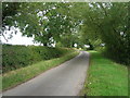
3
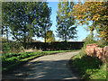
Bend in the Lane near Shoemakers Hill, Fenwick
Image: © Bill Henderson
Taken: 29 Oct 2006
0.07 miles
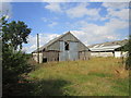
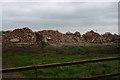
4
The remains of Manor Farm
Just a heap of rubble.
Image: © Jonathan Thacker
Taken: 28 Jul 2014
0.09 miles
5
Buttressed wall
Part of Manor Farm which apart from this wall and one other has been completely demolished.
Image: © Jonathan Thacker
Taken: 28 Jul 2014
0.09 miles
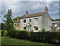
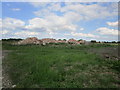
6
Former farm buildings at Manor Farm, Lawn Lane
Image: © Ian S
Taken: 9 Apr 2014
0.09 miles
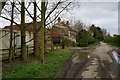
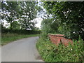
7
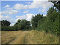
Approaching Lawn Lane
On a farm track which I inadvertently followed rather than the footpath.
Image: © Jonathan Thacker
Taken: 28 Jul 2014
0.12 miles