IMAGES TAKEN NEAR TO
West End Avenue, DONCASTER, DN5 9RG
Introduction
This page details the photographs taken nearby to West End Avenue, DN5 9RG by members of the Geograph project.
The Geograph project started in 2005 with the aim of publishing, organising and preserving representative images for every square kilometre of Great Britain, Ireland and the Isle of Man.

There are currently over 7.5m images from over14,400 individuals and you can help contribute to the project by visiting https://www.geograph.org.uk
Image Map
Images are licensed for reuse under creativecommons.org/licenses/by-sa/2.0
Notes
- Clicking on the map will re-center to the selected point.
- The higher the marker number, the further away the image location is from the centre of the postcode.
Image Listing (14 Images Found)
Images are licensed for reuse under creativecommons.org/licenses/by-sa/2.0
Image
Details
Distance

3
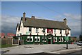
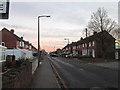
The Drum
The Drum, Watch House Lane, Bentley
Image: © Richard Croft
Taken: 5 Sep 2006
0.13 miles
5
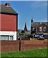
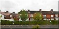
View between houses at Bentley
Looking to St Peter's Church from Watch House Lane.
Image: © Neil Theasby
Taken: 21 Apr 2022
0.15 miles
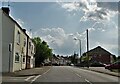
8
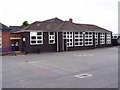
The Front Of Bentley High Street Primary School
Image: © Hall Family
Taken: 30 Jun 2007
0.21 miles
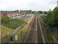
10
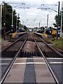
Bentley railway station
As seen from the adjacent level crossing. The station is on the main Doncaster - Leeds branch of the East Coast Mainline but is served only by local trains.
Image: © Graham Hogg
Taken: 26 Sep 2012
0.23 miles