IMAGES TAKEN NEAR TO
Rowan Garth, DONCASTER, DN5 9QQ
Introduction
This page details the photographs taken nearby to Rowan Garth, DN5 9QQ by members of the Geograph project.
The Geograph project started in 2005 with the aim of publishing, organising and preserving representative images for every square kilometre of Great Britain, Ireland and the Isle of Man.

There are currently over 7.5m images from over14,400 individuals and you can help contribute to the project by visiting https://www.geograph.org.uk
Image Map
Images are licensed for reuse under creativecommons.org/licenses/by-sa/2.0
Notes
- Clicking on the map will re-center to the selected point.
- The higher the marker number, the further away the image location is from the centre of the postcode.
Image Listing (12 Images Found)
Images are licensed for reuse under creativecommons.org/licenses/by-sa/2.0
Image
Details
Distance
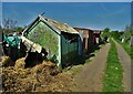
4
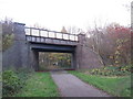
Watchhouse Lane railway bridge over the Doncaster Greenway
Image: © John Slater
Taken: 26 Nov 2013
0.11 miles
5

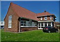
Doncaster Industry Park
A Langtree property, off Watch House Lane.
Image: © Steve Fareham
Taken: 20 Oct 2007
0.15 miles
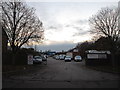
7
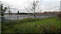
Industry Park that was, but is now a flattened site
Looks like it's been recently cleared and could be redeveloped for housing.
Image: © Chris Morgan
Taken: 26 Sep 2012
0.21 miles
8
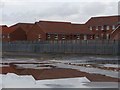
Red brick reflections
New housing reflected in standing water on the adjacent cleared industrial site. This is the day after the area received one month's rainfall in 36 hours.
Image: © Graham Hogg
Taken: 26 Sep 2012
0.22 miles
9
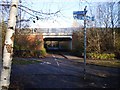
Great North Road Bridge
Point where the A638 Great North Road passes over the Trans Pennine Trail
Image: © Dave Taylor
Taken: 9 Dec 2008
0.23 miles
10
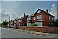
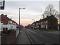
Houses on Watch House Lane, Sunnyfields
Image: © Neil Theasby
Taken: 20 Jul 2021
0.23 miles