IMAGES TAKEN NEAR TO
St. Pauls Parade, DONCASTER, DN5 8LD
Introduction
This page details the photographs taken nearby to St. Pauls Parade, DN5 8LD by members of the Geograph project.
The Geograph project started in 2005 with the aim of publishing, organising and preserving representative images for every square kilometre of Great Britain, Ireland and the Isle of Man.

There are currently over 7.5m images from over14,400 individuals and you can help contribute to the project by visiting https://www.geograph.org.uk
Image Map
Images are licensed for reuse under creativecommons.org/licenses/by-sa/2.0
Notes
- Clicking on the map will re-center to the selected point.
- The higher the marker number, the further away the image location is from the centre of the postcode.
Image Listing (6 Images Found)
Images are licensed for reuse under creativecommons.org/licenses/by-sa/2.0
Image
Details
Distance
2
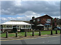
The Mallard
Despite recent events in Germany the England flags are still flying at the Mallard.
Image: © Michael Patterson
Taken: 7 Jul 2006
0.08 miles
3
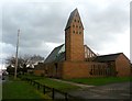
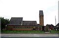
Church of St Leonard and St Jude in Scawsby
Suburban church located on Barnsley Road, Doncaster. The tower resembles an oversized dovecote from this angle.
Image: © Jonathan Clitheroe
Taken: 6 Mar 2017
0.22 miles
4
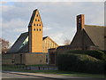
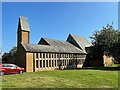
The church of St.Leonard and St. Jude, Scawsby
Designed by G.G. Pace 1957-63. Its predecessor is the building closest to the camera.
Image: © Jonathan Thacker
Taken: 25 Mar 2018
0.22 miles
5
Church of St Leonard and St Jude in Scawsby
Image: © JThomas
Taken: 19 Sep 2022
0.23 miles