IMAGES TAKEN NEAR TO
Crusader Drive, DONCASTER, DN5 7RX
Introduction
This page details the photographs taken nearby to Crusader Drive, DN5 7RX by members of the Geograph project.
The Geograph project started in 2005 with the aim of publishing, organising and preserving representative images for every square kilometre of Great Britain, Ireland and the Isle of Man.

There are currently over 7.5m images from over14,400 individuals and you can help contribute to the project by visiting https://www.geograph.org.uk
Image Map
Images are licensed for reuse under creativecommons.org/licenses/by-sa/2.0
Notes
- Clicking on the map will re-center to the selected point.
- The higher the marker number, the further away the image location is from the centre of the postcode.
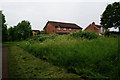
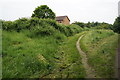
Image Listing (13 Images Found)
Images are licensed for reuse under creativecommons.org/licenses/by-sa/2.0
Image
Details
Distance
4
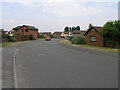
Mini Adventure
The red Mini is heading for another adventure on Challenger Drive, a modern housing development west of Doncaster.
Image: © Michael Patterson
Taken: 5 Jul 2006
0.11 miles
5
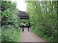
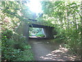
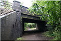
Road Bridge over the Trans Pennine Trail
Image: © Martin Dawes
Taken: 29 Apr 2010
0.14 miles
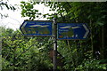
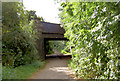
7
Sprotbrough Road goes over The Trans Pennine Trail
Image: © Ian S
Taken: 31 May 2014
0.17 miles