IMAGES TAKEN NEAR TO
Derwent Place, DONCASTER, DN5 7PN
Introduction
This page details the photographs taken nearby to Derwent Place, DN5 7PN by members of the Geograph project.
The Geograph project started in 2005 with the aim of publishing, organising and preserving representative images for every square kilometre of Great Britain, Ireland and the Isle of Man.

There are currently over 7.5m images from over14,400 individuals and you can help contribute to the project by visiting https://www.geograph.org.uk
Image Map
Images are licensed for reuse under creativecommons.org/licenses/by-sa/2.0
Notes
- Clicking on the map will re-center to the selected point.
- The higher the marker number, the further away the image location is from the centre of the postcode.
Image Listing (5 Images Found)
Images are licensed for reuse under creativecommons.org/licenses/by-sa/2.0
Image
Details
Distance
1
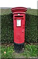
Elizabeth II postbox on Melton Road
Postbox No. DN5 177.
Image: © JThomas
Taken: 19 Sep 2022
0.10 miles
2
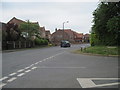
Road Junction in Sprotbrough
Turn right here, the road finishes at fields and a footpath out into open country.
Image: © Martin Dawes
Taken: 29 Apr 2010
0.19 miles
3
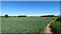
Path running north towards Fox Flat Plantation from Sprotbrough
Image: © Colin Park
Taken: 9 Jun 2021
0.20 miles