IMAGES TAKEN NEAR TO
Brompton Road, DONCASTER, DN5 7LB
Introduction
This page details the photographs taken nearby to Brompton Road, DN5 7LB by members of the Geograph project.
The Geograph project started in 2005 with the aim of publishing, organising and preserving representative images for every square kilometre of Great Britain, Ireland and the Isle of Man.

There are currently over 7.5m images from over14,400 individuals and you can help contribute to the project by visiting https://www.geograph.org.uk
Image Map
Images are licensed for reuse under creativecommons.org/licenses/by-sa/2.0
Notes
- Clicking on the map will re-center to the selected point.
- The higher the marker number, the further away the image location is from the centre of the postcode.
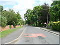
Image Listing (5 Images Found)
Images are licensed for reuse under creativecommons.org/licenses/by-sa/2.0
Image
Details
Distance
1
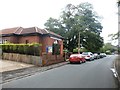
Sprotborough Methodist Church
Situated at the junction of Brompton Road and Park Drive.
Image: © Jonathan Clitheroe
Taken: 11 Jun 2016
0.07 miles
2
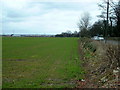
Looking along the line of Melton Road, Sprotbrough
looking eastwards towards Doncaster
Image: © Nigel Homer
Taken: 25 Feb 2006
0.17 miles
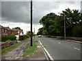
5
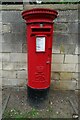
Elizabeth II postbox on Melton Road
Postbox No. DN5 345.
Image: © JThomas
Taken: 19 Sep 2022
0.25 miles