IMAGES TAKEN NEAR TO
Adwick Avenue, DONCASTER, DN5 0RB
Introduction
This page details the photographs taken nearby to Adwick Avenue, DN5 0RB by members of the Geograph project.
The Geograph project started in 2005 with the aim of publishing, organising and preserving representative images for every square kilometre of Great Britain, Ireland and the Isle of Man.

There are currently over 7.5m images from over14,400 individuals and you can help contribute to the project by visiting https://www.geograph.org.uk
Image Map
Images are licensed for reuse under creativecommons.org/licenses/by-sa/2.0
Notes
- Clicking on the map will re-center to the selected point.
- The higher the marker number, the further away the image location is from the centre of the postcode.
Image Listing (19 Images Found)
Images are licensed for reuse under creativecommons.org/licenses/by-sa/2.0
Image
Details
Distance
1
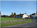
Entering Toll Bar on Adwick lane, from Adwick le Street.
Image: © Bill Henderson
Taken: 29 Oct 2006
0.03 miles
2
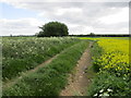
Track and oilseed rape at Toll Bar
Image: © Jonathan Thacker
Taken: 31 May 2015
0.05 miles

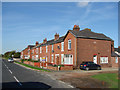
4
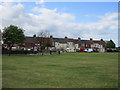
Terrace at Toll Bar
Slightly separated from the main part of the settlement.
Image: © Jonathan Thacker
Taken: 31 May 2015
0.10 miles
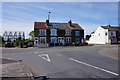
5
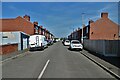
Marton Road - off Adwick Lane, Toll Bar
Image: © Neil Theasby
Taken: 21 Apr 2022
0.10 miles
6
Last houses leaving Toll Bar on Adwick Lane, towards Adwick le Street.
Image: © Bill Henderson
Taken: 29 Oct 2006
0.11 miles
7

A19 Askern Road in Toll Bar
Heading north out of the village.
Image: © Jonathan Clitheroe
Taken: 19 Dec 2015
0.14 miles

9
Askern Road, Toll Bar
Taken from Hall Villa Lane.
Image: © Ian S
Taken: 15 May 2019
0.18 miles
10
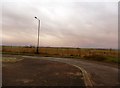
Toll Bar Urban Fringe
Looking over a flat landscape from the edge of the Manor Estate.
Image: © Jonathan Clitheroe
Taken: 19 Dec 2015
0.19 miles