IMAGES TAKEN NEAR TO
The Avenue, DONCASTER, DN5 0NP
Introduction
This page details the photographs taken nearby to The Avenue, DN5 0NP by members of the Geograph project.
The Geograph project started in 2005 with the aim of publishing, organising and preserving representative images for every square kilometre of Great Britain, Ireland and the Isle of Man.

There are currently over 7.5m images from over14,400 individuals and you can help contribute to the project by visiting https://www.geograph.org.uk
Image Map (Loading...)


Getting Data...Please wait
Leaflet Map data © OpenStreetMap
Images are licensed for reuse under creativecommons.org/licenses/by-sa/2.0
Notes
- Clicking on the map will re-center to the selected point.
- The higher the marker number, the further away the image location is from the centre of the postcode.
Image Listing (5 Images Found)
Images are licensed for reuse under creativecommons.org/licenses/by-sa/2.0
Image
Details
Distance
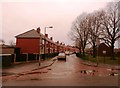
1
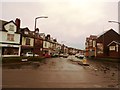
Cobblers Corner
Junction of the Avenue and Arksey Lane in Stockbridge.
Image: © Jonathan Clitheroe
Taken: 12 Dec 2015
0.18 miles
3
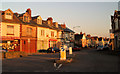
'Cobblers Corner'
47 Arksey Lane, Bentley, near Doncaster
Image: © Steve Fareham
Taken: 20 Oct 2007
0.21 miles
4
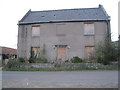
Stockbridge Farmhouse
In poor condition and surrounded by caravan sites. http://www.britishlistedbuildings.co.uk/en-334926-stockbridge-farmhouse-
Image: © Jonathan Thacker
Taken: 9 Nov 2012
0.24 miles
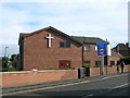
5
The Homestead in Bentley
Pictured from its junction with Arksey Lane.
Image: © Jonathan Clitheroe
Taken: 12 Dec 2015
0.25 miles