IMAGES TAKEN NEAR TO
Haywood, DONCASTER, DN5 0NA
Introduction
This page details the photographs taken nearby to Haywood, DN5 0NA by members of the Geograph project.
The Geograph project started in 2005 with the aim of publishing, organising and preserving representative images for every square kilometre of Great Britain, Ireland and the Isle of Man.

There are currently over 7.5m images from over14,400 individuals and you can help contribute to the project by visiting https://www.geograph.org.uk
Image Map
Images are licensed for reuse under creativecommons.org/licenses/by-sa/2.0
Notes
- Clicking on the map will re-center to the selected point.
- The higher the marker number, the further away the image location is from the centre of the postcode.
Image Listing (9 Images Found)
Images are licensed for reuse under creativecommons.org/licenses/by-sa/2.0
Image
Details
Distance
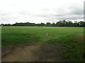
5
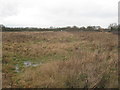
Abandoned field near Blacker Green
Image: © Jonathan Thacker
Taken: 28 Dec 2012
0.10 miles
6
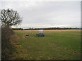
Field off Thorpe Grange Lane
Rather fewer surrounding trees than is usual in this area.
Image: © Jonathan Thacker
Taken: 28 Dec 2012
0.16 miles
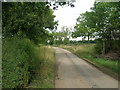
7
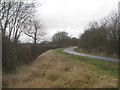
Thorpe Grange Lane
Narrow and with a steep drop in to a drain. The almost blind bend is repeated several times in the next mile or two.
Image: © Jonathan Thacker
Taken: 28 Dec 2012
0.18 miles