IMAGES TAKEN NEAR TO
Tilts, DONCASTER, DN5 0LJ
Introduction
This page details the photographs taken nearby to Tilts, DN5 0LJ by members of the Geograph project.
The Geograph project started in 2005 with the aim of publishing, organising and preserving representative images for every square kilometre of Great Britain, Ireland and the Isle of Man.

There are currently over 7.5m images from over14,400 individuals and you can help contribute to the project by visiting https://www.geograph.org.uk
Image Map
Images are licensed for reuse under creativecommons.org/licenses/by-sa/2.0
Notes
- Clicking on the map will re-center to the selected point.
- The higher the marker number, the further away the image location is from the centre of the postcode.
Image Listing (22 Images Found)
Images are licensed for reuse under creativecommons.org/licenses/by-sa/2.0
Image
Details
Distance
1
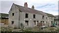
Old farm cottages at Tilts
Good roof, not so good windows and interior!
Image: © Chris Morgan
Taken: 26 Sep 2012
0.06 miles
3
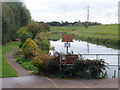
Fishing place on Smallholm and Tilts Drain
The local angling club like to keep this to themselves!
Image: © Graham Hogg
Taken: 26 Sep 2012
0.07 miles
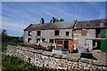
5
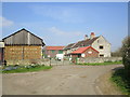
Tilts West Farm
The farm is in use but the farmhouse has been abandoned.
Image: © Jonathan Thacker
Taken: 20 Apr 2015
0.07 miles
9
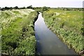
From Tilts Bridge
Looking northwest along Smallholme & Tilts drain
Image: © Richard Croft
Taken: 31 May 2006
0.10 miles
10
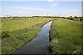
Smallholme & Tilts drain
Looking southeast from Tilts Bridge
Image: © Richard Croft
Taken: 31 May 2006
0.10 miles