IMAGES TAKEN NEAR TO
Askern Road, DONCASTER, DN5 0EA
Introduction
This page details the photographs taken nearby to Askern Road, DN5 0EA by members of the Geograph project.
The Geograph project started in 2005 with the aim of publishing, organising and preserving representative images for every square kilometre of Great Britain, Ireland and the Isle of Man.

There are currently over 7.5m images from over14,400 individuals and you can help contribute to the project by visiting https://www.geograph.org.uk
Image Map
Images are licensed for reuse under creativecommons.org/licenses/by-sa/2.0
Notes
- Clicking on the map will re-center to the selected point.
- The higher the marker number, the further away the image location is from the centre of the postcode.
Image Listing (25 Images Found)
Images are licensed for reuse under creativecommons.org/licenses/by-sa/2.0
Image
Details
Distance
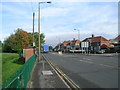
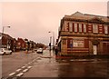
4
The Homestead in Bentley
Pictured from its junction with Arksey Lane.
Image: © Jonathan Clitheroe
Taken: 12 Dec 2015
0.08 miles
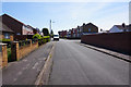
5
Junction of Mill Gate and the A19 in Bentley
Image: © Jonathan Clitheroe
Taken: 12 Dec 2015
0.11 miles
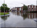
9
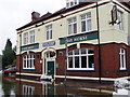
The Bay Horse In Bentley During The 2007 Floods
Image: © Hall Family
Taken: 30 Jun 2007
0.15 miles
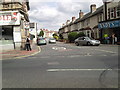
10
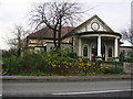
The Pavilion, Function and Exhibition Centre
Image: © Bill Henderson
Taken: 30 Nov 2006
0.16 miles