IMAGES TAKEN NEAR TO
Church Lane, DONCASTER, DN4 9NN
Introduction
This page details the photographs taken nearby to Church Lane, DN4 9NN by members of the Geograph project.
The Geograph project started in 2005 with the aim of publishing, organising and preserving representative images for every square kilometre of Great Britain, Ireland and the Isle of Man.

There are currently over 7.5m images from over14,400 individuals and you can help contribute to the project by visiting https://www.geograph.org.uk
Image Map (Loading...)


Getting Data...Please wait
Leaflet Map data © OpenStreetMap
Images are licensed for reuse under creativecommons.org/licenses/by-sa/2.0
Notes
- Clicking on the map will re-center to the selected point.
- The higher the marker number, the further away the image location is from the centre of the postcode.
Image Listing (41 Images Found)
Images are licensed for reuse under creativecommons.org/licenses/by-sa/2.0
Image
Details
Distance

5
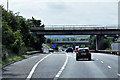
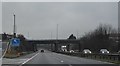
Warmsworth : A1(M)
Looking along the A1(M) heading northbound.
Image: © Lewis Clarke
Taken: 21 Sep 2020
0.09 miles
6

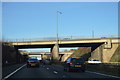
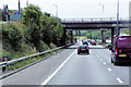
A1(M) - four bridges
First a footbridge, then two bridges for the junction 36 roundabout, finally Tenter Lane Bridge.
Image: © Robin Webster
Taken: 7 Oct 2011
0.10 miles