IMAGES TAKEN NEAR TO
Ormsby Close, DONCASTER, DN4 9BD
Introduction
This page details the photographs taken nearby to Ormsby Close, DN4 9BD by members of the Geograph project.
The Geograph project started in 2005 with the aim of publishing, organising and preserving representative images for every square kilometre of Great Britain, Ireland and the Isle of Man.

There are currently over 7.5m images from over14,400 individuals and you can help contribute to the project by visiting https://www.geograph.org.uk
Image Map
Images are licensed for reuse under creativecommons.org/licenses/by-sa/2.0
Notes
- Clicking on the map will re-center to the selected point.
- The higher the marker number, the further away the image location is from the centre of the postcode.
Image Listing (8 Images Found)
Images are licensed for reuse under creativecommons.org/licenses/by-sa/2.0
Image
Details
Distance
2
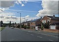
Bus terminus, Alverley Lane, Doncaster
For the half hourly First South Yorkshire No 16.
Image: © Chris Morgan
Taken: 13 Jan 2023
0.19 miles
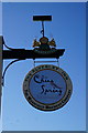
4
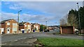
China Spring on Springwell Lane, Doncaster
Formerly the Alverley Inn public house.
Image: © Ian S
Taken: 17 May 2014
0.22 miles
6
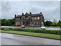
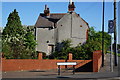
St Catherines Hospital, Doncaster
A Mental Healthcare Hospital belonging to Rotherham Doncaster and South Humber NHS Foundation Trust.
It was built in 1839.
Image: © J.Hannan
Taken: 8 Jun 2019
0.23 miles
7

Path and Former Railway Line
Course of the former mineral line which served Yorkshire Main Colliery. The path is now a well-used recreational path despite it not being formally marked as such on the map.
Image: © Jonathan Clitheroe
Taken: 2 Nov 2016
0.24 miles
8
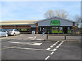
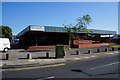
ASDA supermarket
The new Balby store which opened in June of 2011. The opening ceremony was performed by guests from the Balby Children’s Centre.
Image: © Jonathan Wilkins
Taken: 28 Oct 2011
0.25 miles