IMAGES TAKEN NEAR TO
Ryton Way, DONCASTER, DN4 6PS
Introduction
This page details the photographs taken nearby to Ryton Way, DN4 6PS by members of the Geograph project.
The Geograph project started in 2005 with the aim of publishing, organising and preserving representative images for every square kilometre of Great Britain, Ireland and the Isle of Man.

There are currently over 7.5m images from over14,400 individuals and you can help contribute to the project by visiting https://www.geograph.org.uk
Image Map
Images are licensed for reuse under creativecommons.org/licenses/by-sa/2.0
Notes
- Clicking on the map will re-center to the selected point.
- The higher the marker number, the further away the image location is from the centre of the postcode.
Image Listing (5 Images Found)
Images are licensed for reuse under creativecommons.org/licenses/by-sa/2.0
Image
Details
Distance
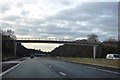
1
Footbridge over the M18, Hatchell Wood
The bridge carries the footpath between Ryton Way, on the west side of the M18, to Muirfield Avenue, on the east side, at the northern end of Hatchell Wood
Image: © David Dixon
Taken: 14 Oct 2011
0.08 miles
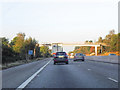
3
Footbridge over M18 southbound at Bessacarr
Image: © Martin Dawes
Taken: 19 May 2021
0.09 miles
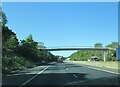
4
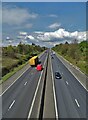
The M18 motorway at Cantley, Doncaster
Image: © Neil Theasby
Taken: 30 Apr 2021
0.10 miles