IMAGES TAKEN NEAR TO
The Woodlands, GRIMSBY, DN41 8BH
Introduction
This page details the photographs taken nearby to The Woodlands, DN41 8BH by members of the Geograph project.
The Geograph project started in 2005 with the aim of publishing, organising and preserving representative images for every square kilometre of Great Britain, Ireland and the Isle of Man.

There are currently over 7.5m images from over14,400 individuals and you can help contribute to the project by visiting https://www.geograph.org.uk
Image Map
Images are licensed for reuse under creativecommons.org/licenses/by-sa/2.0
Notes
- Clicking on the map will re-center to the selected point.
- The higher the marker number, the further away the image location is from the centre of the postcode.
Image Listing (33 Images Found)
Images are licensed for reuse under creativecommons.org/licenses/by-sa/2.0
Image
Details
Distance
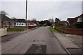
2
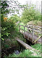
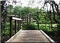
Two bridges
Interesting to what once was considered adequate alongside its succcessor.
Image: © Jonathan Thacker
Taken: 27 Mar 2011
0.10 miles
3
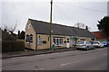
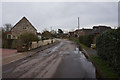
Stallingborough Village Store
Station Road, Stallingborough.
Image: © Ian S
Taken: 8 Mar 2017
0.13 miles
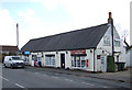
5
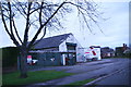
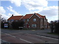
Business for sale in Stallingborough
A grey December afternoon just before Christmas. At first I thought it was tinsel on the top of the gates!
Image: © Chris
Taken: 14 Dec 2014
0.13 miles
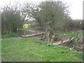
8
The Church Path, Stallingborough
One of many footbridges on the footpath between the Church of St Pater & St Paul and the railway station at Stallingborough. There are three older bridges on the Ordnance Survey 1:25000 scale map but there is now a bridge on almost every field boundary.
Image: © Paul Glazzard
Taken: 3 May 2008
0.15 miles
10
The Church Path, Stallingborough
One of many footbridges on the footpath between the Church of St Peter & St Paul and the railway station at Stallingborough. There are three older bridges on the Ordnance Survey 1:25000 scale map but there is now a bridge on almost every field boundary.
Image: © Paul Glazzard
Taken: 3 May 2008
0.16 miles