IMAGES TAKEN NEAR TO
Leggott Way, GRIMSBY, DN41 8BB
Introduction
This page details the photographs taken nearby to Leggott Way, DN41 8BB by members of the Geograph project.
The Geograph project started in 2005 with the aim of publishing, organising and preserving representative images for every square kilometre of Great Britain, Ireland and the Isle of Man.

There are currently over 7.5m images from over14,400 individuals and you can help contribute to the project by visiting https://www.geograph.org.uk
Image Map
Images are licensed for reuse under creativecommons.org/licenses/by-sa/2.0
Notes
- Clicking on the map will re-center to the selected point.
- The higher the marker number, the further away the image location is from the centre of the postcode.
Image Listing (44 Images Found)
Images are licensed for reuse under creativecommons.org/licenses/by-sa/2.0
Image
Details
Distance
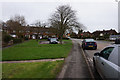
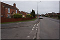
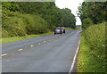
2
Station Road, Stallingborough
Heading east.
Image: © JThomas
Taken: 30 Mar 2013
0.05 miles
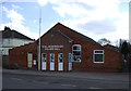
4
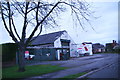
Business for sale in Stallingborough
A grey December afternoon just before Christmas. At first I thought it was tinsel on the top of the gates!
Image: © Chris
Taken: 14 Dec 2014
0.06 miles
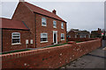
6
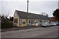
Stallingborough Village Store
Station Road, Stallingborough.
Image: © Ian S
Taken: 8 Mar 2017
0.11 miles
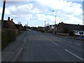
8
Heading east along the B1210 Healing Road
Image: © Mat Fascione
Taken: 23 Jul 2016
0.12 miles
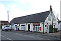
9
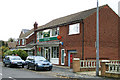
Stallingborough Post Office
Stallingborough Post Office and Convenience Store which is about 100 yards SW of the station.
Image: © David Wright
Taken: 19 Oct 2005
0.14 miles