IMAGES TAKEN NEAR TO
Beaconsfield Road, DONCASTER, DN4 0DL
Introduction
This page details the photographs taken nearby to Beaconsfield Road, DN4 0DL by members of the Geograph project.
The Geograph project started in 2005 with the aim of publishing, organising and preserving representative images for every square kilometre of Great Britain, Ireland and the Isle of Man.

There are currently over 7.5m images from over14,400 individuals and you can help contribute to the project by visiting https://www.geograph.org.uk
Image Map
Images are licensed for reuse under creativecommons.org/licenses/by-sa/2.0
Notes
- Clicking on the map will re-center to the selected point.
- The higher the marker number, the further away the image location is from the centre of the postcode.
Image Listing (27 Images Found)
Images are licensed for reuse under creativecommons.org/licenses/by-sa/2.0
Image
Details
Distance
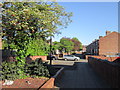
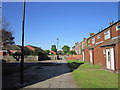
6
Flats on Old Hexthorpe
The 1966 map still shows this area as allotment gardens, so I would put these flat-roofed low-rise buildings as probably early 1970s.
Image: © Stephen Craven
Taken: 16 Mar 2024
0.10 miles
9
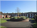
The flower bed on Barnstone Street, Hexthorpe
Image: © Ian S
Taken: 12 May 2012
0.12 miles