IMAGES TAKEN NEAR TO
Clough Lane, IMMINGHAM, DN40 3JS
Introduction
This page details the photographs taken nearby to Clough Lane, DN40 3JS by members of the Geograph project.
The Geograph project started in 2005 with the aim of publishing, organising and preserving representative images for every square kilometre of Great Britain, Ireland and the Isle of Man.

There are currently over 7.5m images from over14,400 individuals and you can help contribute to the project by visiting https://www.geograph.org.uk
Image Map
Images are licensed for reuse under creativecommons.org/licenses/by-sa/2.0
Notes
- Clicking on the map will re-center to the selected point.
- The higher the marker number, the further away the image location is from the centre of the postcode.
Image Listing (38 Images Found)
Images are licensed for reuse under creativecommons.org/licenses/by-sa/2.0
Image
Details
Distance
1
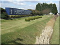
Overgrown railway tracks crossing Haven Road, Killingholme Haven
Image: © Chris
Taken: 21 Jul 2016
0.05 miles
2
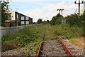
Remnant of the Barton & Immingham Light Railway
Although this rail line now terminates in about 1km it was once part of the Barton & Immingham Light Railway which opened in 1911. This linked Immingham with Hull via the Humber ferry at New Holland by joining with the Barton to Grimsby line near Goxhill. It closed in 1963 when the Humber bridge opened. The Immingham to Killingholme section is however still used for oil traffic.
Image: © David Wright
Taken: 14 Jun 2008
0.07 miles
3
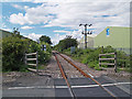
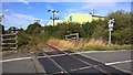
Single track railway
The single line looking north-westwards from the level crossing on the approach road to the haven, the track passes between storage sheds on the Humber Sea Terminal port complex which occupies much of the land west of the road.
Image: © George Robinson
Taken: 21 Apr 2007
0.07 miles
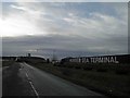
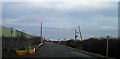
5
Level crossing, Haven Road, North Killingholme
Many, many truck loads of freight pass through Killingholme, but nothing goes by rail
Image: © Chris Morgan
Taken: 18 Sep 2018
0.08 miles
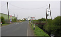
6
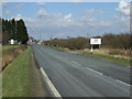
Haven Road
Towards North Killingholme Haven.
Image: © JThomas
Taken: 30 Mar 2013
0.08 miles
8
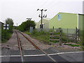
Ungated Railway Crossing
This ungated crossing carries a single-track line across the road to Killingholme Haven, the track looks used but I have never seen what type of rail traffic uses this line. On the right, a bridge over a land drain which runs parallel to the road at this point.
Image: © George Robinson
Taken: 21 Apr 2007
0.09 miles
9
Rail crossing ahead on Haven Road, Immingham
Image: © Steve Fareham
Taken: 12 Jan 2014
0.09 miles