IMAGES TAKEN NEAR TO
Killingholme Road, IMMINGHAM, DN40 3BA
Introduction
This page details the photographs taken nearby to Killingholme Road, DN40 3BA by members of the Geograph project.
The Geograph project started in 2005 with the aim of publishing, organising and preserving representative images for every square kilometre of Great Britain, Ireland and the Isle of Man.

There are currently over 7.5m images from over14,400 individuals and you can help contribute to the project by visiting https://www.geograph.org.uk
Image Map (Loading...)


Getting Data...Please wait
Leaflet Map data © OpenStreetMap
Images are licensed for reuse under creativecommons.org/licenses/by-sa/2.0
Notes
- Clicking on the map will re-center to the selected point.
- The higher the marker number, the further away the image location is from the centre of the postcode.
Image Listing (6 Images Found)
Images are licensed for reuse under creativecommons.org/licenses/by-sa/2.0
Image
Details
Distance
5

The Vicarage
Surrounded by trees and foliage, this is a rear view of the same building seen on Image
Image: © John Beal
Taken: 22 Apr 2008
0.24 miles
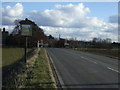
6
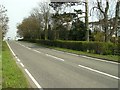
Road to South Killingholme
Heading out of Habrough. The large house is, or was, a vicarage.
Image: © John Beal
Taken: 22 Apr 2008
0.24 miles