IMAGES TAKEN NEAR TO
West Riverside, IMMINGHAM, DN40 2YB
Introduction
This page details the photographs taken nearby to West Riverside, DN40 2YB by members of the Geograph project.
The Geograph project started in 2005 with the aim of publishing, organising and preserving representative images for every square kilometre of Great Britain, Ireland and the Isle of Man.

There are currently over 7.5m images from over14,400 individuals and you can help contribute to the project by visiting https://www.geograph.org.uk
Image Map (Loading...)


Getting Data...Please wait
Leaflet Map data © OpenStreetMap
Images are licensed for reuse under creativecommons.org/licenses/by-sa/2.0
Notes
- Clicking on the map will re-center to the selected point.
- The higher the marker number, the further away the image location is from the centre of the postcode.
Image Listing (4 Images Found)
Images are licensed for reuse under creativecommons.org/licenses/by-sa/2.0
Image
Details
Distance
1
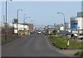
North western road
Road access along the north-western side of the dock, the road passes between ro-ro terminals and tank storage before eventually leading to the western side of the lock entrance.
Image: © George Robinson
Taken: 28 Apr 2007
0.13 miles
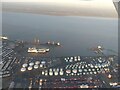
4
DFDS freight ferry at South Killingholme Haven
Seen at dusk from a Hull - Zeebrugge ferry.
Image: © Christine Johnstone
Taken: 13 Sep 2012
0.23 miles