IMAGES TAKEN NEAR TO
Manby Road, IMMINGHAM, DN40 2LJ
Introduction
This page details the photographs taken nearby to Manby Road, DN40 2LJ by members of the Geograph project.
The Geograph project started in 2005 with the aim of publishing, organising and preserving representative images for every square kilometre of Great Britain, Ireland and the Isle of Man.

There are currently over 7.5m images from over14,400 individuals and you can help contribute to the project by visiting https://www.geograph.org.uk
Image Map (Loading...)


Getting Data...Please wait
Leaflet Map data © OpenStreetMap
Images are licensed for reuse under creativecommons.org/licenses/by-sa/2.0
Notes
- Clicking on the map will re-center to the selected point.
- The higher the marker number, the further away the image location is from the centre of the postcode.
Image Listing (7 Images Found)
Images are licensed for reuse under creativecommons.org/licenses/by-sa/2.0
Image
Details
Distance
1
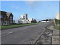
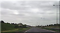
Manby Road, Immingham
The main road into and out of the town, just before the dual carriageway section, though, at the time, relatively quiet due to the ongoing roadworks on the A160 restricting eastbound traffic.
Image: © Paul Harrop
Taken: 19 Feb 2017
0.05 miles
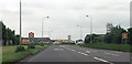
4
Junction for town centre from Manby Road
Image: © John Firth
Taken: 10 Jun 2013
0.14 miles
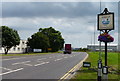
6
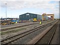
DFDS depot, Immingham
Taken from a passing excursion train.
Image: © Nigel Thompson
Taken: 26 Oct 2013
0.23 miles
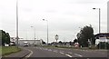
7
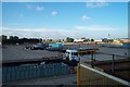
Industrial Land bordering Immingham Docks
Industrial area close to Immingham Docks, however most of the industry in view supports construction and maintenance activities on local Humberside process plants and refineries. Also visible is a housing estate in Immingham.
Image: © Martyn Whiteley
Taken: 10 Jul 2001
0.24 miles