IMAGES TAKEN NEAR TO
Kings Road, IMMINGHAM, DN40 1AL
Introduction
This page details the photographs taken nearby to Kings Road, DN40 1AL by members of the Geograph project.
The Geograph project started in 2005 with the aim of publishing, organising and preserving representative images for every square kilometre of Great Britain, Ireland and the Isle of Man.

There are currently over 7.5m images from over14,400 individuals and you can help contribute to the project by visiting https://www.geograph.org.uk
Image Map
Images are licensed for reuse under creativecommons.org/licenses/by-sa/2.0
Notes
- Clicking on the map will re-center to the selected point.
- The higher the marker number, the further away the image location is from the centre of the postcode.
Image Listing (31 Images Found)
Images are licensed for reuse under creativecommons.org/licenses/by-sa/2.0
Image
Details
Distance
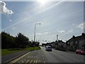
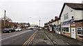
2
Solway Club on corner of Trenchard Close
Image: © John Firth
Taken: 10 Jun 2013
0.03 miles
3
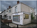
Tattoo Studio, Immingham
I guess this was once the typical corner shop.
Image: © Jonathan Thacker
Taken: 27 Aug 2011
0.04 miles
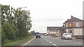
4
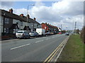
Immingham: Kings Road, a resting truck and the Solway Club
Image: © Chris
Taken: 15 Feb 2015
0.04 miles
6
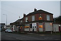
The Solway Club on King's Road, Immingham
Image: © Chris
Taken: 15 Feb 2015
0.04 miles
7
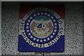
Sign on the wall of the Solway Club, Immingham
Detail of Image For Missouri Raiders see http://missouriraiders.webplus.net/
Image: © Chris
Taken: 15 Feb 2015
0.04 miles
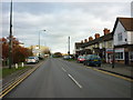
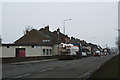
10
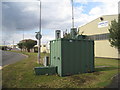
Air Quality Monitoring Station
At the junction of King's Road and Pelham Road.
Image: © Jonathan Thacker
Taken: 27 Aug 2011
0.06 miles