IMAGES TAKEN NEAR TO
Williams Drive, ULCEBY, DN39 6UE
Introduction
This page details the photographs taken nearby to Williams Drive, DN39 6UE by members of the Geograph project.
The Geograph project started in 2005 with the aim of publishing, organising and preserving representative images for every square kilometre of Great Britain, Ireland and the Isle of Man.

There are currently over 7.5m images from over14,400 individuals and you can help contribute to the project by visiting https://www.geograph.org.uk
Image Map
Images are licensed for reuse under creativecommons.org/licenses/by-sa/2.0
Notes
- Clicking on the map will re-center to the selected point.
- The higher the marker number, the further away the image location is from the centre of the postcode.
Image Listing (13 Images Found)
Images are licensed for reuse under creativecommons.org/licenses/by-sa/2.0
Image
Details
Distance
1
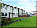
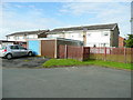
Housing in Williams Drive, Ulceby
The housing is orientated with the garages and rear gardens fronting the road.
These frontages face Walkers Way. The housing to the right is on Martins Road.
Image: © Jonathan Billinger
Taken: 29 Jul 2009
0.03 miles
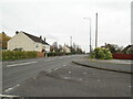
2
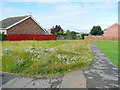
Housing west of Martins Road, Ulceby
As children we used this land before it was built on, as our playground!
Image: © Jonathan Billinger
Taken: 29 Jul 2009
0.04 miles
3
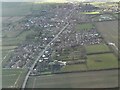
Ulceby, North Lincolnshire: aerial 2022
Image: © Simon Tomson
Taken: 6 Mar 2022
0.06 miles
4
Walkers Way, Ulceby 1
Now very much down-at-heel, this estate was home for me from 1969 to 1977. Our house was Number 14 - the middle of the three here.
When first built, most of the houses had American families as they were requisitioned for the Conoco employees overseeing the construction of the oil refinery at South Killingholme - see Image
Happy days!
Image: © Jonathan Billinger
Taken: 29 Jul 2009
0.07 miles
5
Walkers Way, Ulceby 2
The other side of the street, opposite where I used to live - see Image
Image: © Jonathan Billinger
Taken: 29 Jul 2009
0.07 miles
6
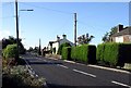
Ulceby, N.Lincs.
The A1077 is the main road through Ulceby. Picture taken on the eastern edge of the village, looking west.
Image: © Lynne Kirton
Taken: 25 Oct 2005
0.08 miles
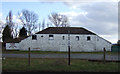
9
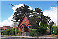
Ulceby Seventh Day Adventist Church
The inscription above the porch records that the church was built in 1888.
Image: © David Wright
Taken: 12 May 2007
0.19 miles
10
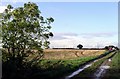
Farmland near Ulceby
North of the village, looking north. Not much other than flat fields and the odd tree in this square.
Image: © Lynne Kirton
Taken: 25 Oct 2005
0.20 miles