IMAGES TAKEN NEAR TO
High Street, ULCEBY, DN39 6RW
Introduction
This page details the photographs taken nearby to High Street, DN39 6RW by members of the Geograph project.
The Geograph project started in 2005 with the aim of publishing, organising and preserving representative images for every square kilometre of Great Britain, Ireland and the Isle of Man.

There are currently over 7.5m images from over14,400 individuals and you can help contribute to the project by visiting https://www.geograph.org.uk
Image Map (Loading...)


Getting Data...Please wait
Leaflet Map data © OpenStreetMap
Images are licensed for reuse under creativecommons.org/licenses/by-sa/2.0
Notes
- Clicking on the map will re-center to the selected point.
- The higher the marker number, the further away the image location is from the centre of the postcode.
Image Listing (30 Images Found)
Images are licensed for reuse under creativecommons.org/licenses/by-sa/2.0
Image
Details
Distance
1
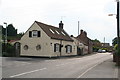
Wootton: corner of High Street and Cherry Lane
Image: © Chris
Taken: 12 Jul 2014
0.01 miles
3
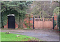
Gateway, Old Vicarage, Wootton
This gateway and flanking wall, including the pedestrian doorway, are listed. For further information see http://www.imagesofengland.org.uk/details/default.aspx?id=165946
Image: © David Wright
Taken: 8 Dec 2009
0.15 miles
5
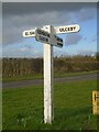
Direction Sign ? Signpost close to Wootton
Located on the grass triangle in the centre of the crossroads west of the village in Wootton parish. 4 arms but no finial. See also https://www.geograph.org.uk/photo/1912848.
Milestone Society National ID: LI_TA0816
Image: © C Minto
Taken: 15 Feb 2022
0.18 miles
7
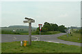
Wootton crossroads
The timber fingerpost is typical of the type to be found in this area.
Image: © Alan Murray-Rust
Taken: 11 Jun 2010
0.18 miles
8
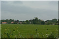
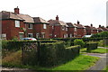
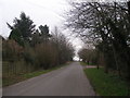
View from Swallow Lane
Looking across the fields towards Wootton village.
Image: © Alan Murray-Rust
Taken: 11 Jun 2010
0.19 miles

10
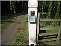
Bloody Gate, Wootton, detail
The plaque reads : "Bloody Gate" so called until 1825 when the original public way from Wootton to Thornton was superseded by the existing road.
It still doesn't answer the question though: Why Bloody Gate ?
Image: © Jonathan Thacker
Taken: 22 Aug 2011
0.21 miles