IMAGES TAKEN NEAR TO
St. Nicholas Drive, GRIMSBY, DN37 9QF
Introduction
This page details the photographs taken nearby to St. Nicholas Drive, DN37 9QF by members of the Geograph project.
The Geograph project started in 2005 with the aim of publishing, organising and preserving representative images for every square kilometre of Great Britain, Ireland and the Isle of Man.

There are currently over 7.5m images from over14,400 individuals and you can help contribute to the project by visiting https://www.geograph.org.uk
Image Map (Loading...)


Getting Data...Please wait
Leaflet Map data © OpenStreetMap
Images are licensed for reuse under creativecommons.org/licenses/by-sa/2.0
Notes
- Clicking on the map will re-center to the selected point.
- The higher the marker number, the further away the image location is from the centre of the postcode.
Image Listing (12 Images Found)
Images are licensed for reuse under creativecommons.org/licenses/by-sa/2.0
Image
Details
Distance
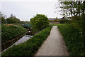
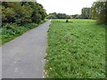
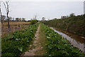
1
Wybers Wood
Footpath and footbridge over the River Freshney by Wybers Wood housing estate
Image: © Richard Croft
Taken: 15 Jun 2006
0.10 miles
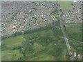
3
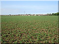
View towards Wybers Wood
Wybers Wood is both a housing estate and a nearby wood. Only the former is in this picture.
Image: © Jonathan Thacker
Taken: 27 May 2016
0.14 miles
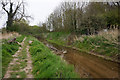
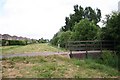
6

Bridge over the River Freshney
At Tonnant Way, Grimsby.
Image: © Ian S
Taken: 24 Apr 2019
0.22 miles