IMAGES TAKEN NEAR TO
Scrub Holt, GRIMSBY, DN37 7LB
Introduction
This page details the photographs taken nearby to Scrub Holt, DN37 7LB by members of the Geograph project.
The Geograph project started in 2005 with the aim of publishing, organising and preserving representative images for every square kilometre of Great Britain, Ireland and the Isle of Man.

There are currently over 7.5m images from over14,400 individuals and you can help contribute to the project by visiting https://www.geograph.org.uk
Image Map (Loading...)


Getting Data...Please wait
Leaflet Map data © OpenStreetMap
Images are licensed for reuse under creativecommons.org/licenses/by-sa/2.0
Notes
- Clicking on the map will re-center to the selected point.
- The higher the marker number, the further away the image location is from the centre of the postcode.
Image Listing (18 Images Found)
Images are licensed for reuse under creativecommons.org/licenses/by-sa/2.0
Image
Details
Distance
1
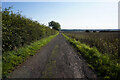
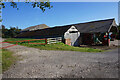
Farm track (bridleway) heading east near Scrub Holt Farm
Towards the A18 (old Roman Road).
Image: © JThomas
Taken: 12 Apr 2014
0.02 miles
2
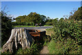
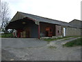
Scrub Holt Farm
The rough-looking trackway to the left forms the bridleway to Irby, which climbs for most of its length. Out of sight to the right is a camping/caravanning area.
Image: © John Beal
Taken: 5 Apr 2007
0.02 miles
8
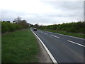
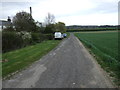
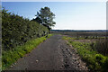
Barton Street (A18)
Heading north east on the old Roman Road towards Grimsby.
Image: © JThomas
Taken: 12 Apr 2014
0.11 miles