IMAGES TAKEN NEAR TO
Middlethorpe Road, CLEETHORPES, DN35 9QD
Introduction
This page details the photographs taken nearby to Middlethorpe Road, DN35 9QD by members of the Geograph project.
The Geograph project started in 2005 with the aim of publishing, organising and preserving representative images for every square kilometre of Great Britain, Ireland and the Isle of Man.

There are currently over 7.5m images from over14,400 individuals and you can help contribute to the project by visiting https://www.geograph.org.uk
Image Map (Loading...)


Getting Data...Please wait
Leaflet Map data © OpenStreetMap
Images are licensed for reuse under creativecommons.org/licenses/by-sa/2.0
Notes
- Clicking on the map will re-center to the selected point.
- The higher the marker number, the further away the image location is from the centre of the postcode.
Image Listing (14 Images Found)
Images are licensed for reuse under creativecommons.org/licenses/by-sa/2.0
Image
Details
Distance
1
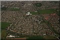
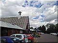
Housing between the A1031 and the A1098: aerial 2016
Pennell's Garden Centre bottom left.
Image: © Chris
Taken: 19 Apr 2016
0.08 miles
2
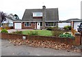
Typical house on Denby Drive, Cleethorpes
Image: © Neil Theasby
Taken: 28 Oct 2014
0.14 miles
3
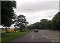
Brian Avenue junction from Humberston Road
Image: © John Firth
Taken: 16 Jun 2012
0.15 miles
4
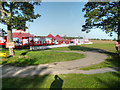
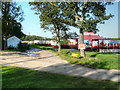
Entrance to Garden Centre
From Humberstone Road
Image: © John Firth
Taken: 10 Jun 2013
0.15 miles

8
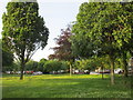
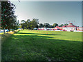
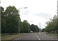
Amenity grass and trees
Between the old and new routes of Humberstone Road. The houses beyond are on Denby Drive.
Image: © Jonathan Thacker
Taken: 9 Jun 2017
0.17 miles