IMAGES TAKEN NEAR TO
Philip Avenue, CLEETHORPES, DN35 9DQ
Introduction
This page details the photographs taken nearby to Philip Avenue, DN35 9DQ by members of the Geograph project.
The Geograph project started in 2005 with the aim of publishing, organising and preserving representative images for every square kilometre of Great Britain, Ireland and the Isle of Man.

There are currently over 7.5m images from over14,400 individuals and you can help contribute to the project by visiting https://www.geograph.org.uk
Image Map (Loading...)


Getting Data...Please wait
Leaflet Map data © OpenStreetMap
Images are licensed for reuse under creativecommons.org/licenses/by-sa/2.0
Notes
- Clicking on the map will re-center to the selected point.
- The higher the marker number, the further away the image location is from the centre of the postcode.
Image Listing (15 Images Found)
Images are licensed for reuse under creativecommons.org/licenses/by-sa/2.0
Image
Details
Distance
1
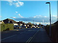
North end of Brian Avenue, Cleethorpes
Off Sandringham Road.
Image: © Richard Vince
Taken: 24 Feb 2024
0.17 miles
2
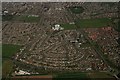
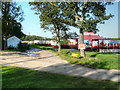
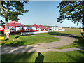
Housing between the A1031 and the A1098: aerial 2016
Pennell's Garden Centre bottom left.
Image: © Chris
Taken: 19 Apr 2016
0.17 miles
4
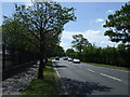
Sandringham Road, Cleethorpes (1)
Looking towards the town centre from its junction with Brian Avenue.
Image: © Richard Vince
Taken: 24 Feb 2024
0.19 miles
5
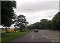
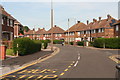
Brian Avenue junction from Humberston Road
Image: © John Firth
Taken: 16 Jun 2012
0.19 miles

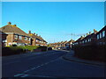
10
Sandringham Road, Cleethorpes
Junction with Brian Avenue.
Image: © Chris
Taken: 6 Jun 2014
0.21 miles