IMAGES TAKEN NEAR TO
Saunby Grove, CLEETHORPES, DN35 8BG
Introduction
This page details the photographs taken nearby to Saunby Grove, DN35 8BG by members of the Geograph project.
The Geograph project started in 2005 with the aim of publishing, organising and preserving representative images for every square kilometre of Great Britain, Ireland and the Isle of Man.

There are currently over 7.5m images from over14,400 individuals and you can help contribute to the project by visiting https://www.geograph.org.uk
Image Map (Loading...)


Getting Data...Please wait
Leaflet Map data © OpenStreetMap
Images are licensed for reuse under creativecommons.org/licenses/by-sa/2.0
Notes
- Clicking on the map will re-center to the selected point.
- The higher the marker number, the further away the image location is from the centre of the postcode.
Image Listing (165 Images Found)
Images are licensed for reuse under creativecommons.org/licenses/by-sa/2.0
Image
Details
Distance
1
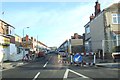
Little windmills in Norfolk Lane
Builders' merchant.
Image: © Chris
Taken: 21 Mar 2014
0.07 miles
2
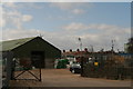
Norfolk Lane: Cold Store and view of the water tower
Image: © Chris
Taken: 21 Mar 2014
0.10 miles
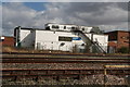
3
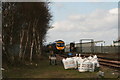
Departing train, birch trees and building materials
A few hundred metres from Cleethorpes Station.
Image: © Chris
Taken: 21 Mar 2014
0.11 miles
4
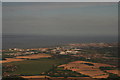
Grimsby and west: aerial 2015
Humber Gateway Windfarm on the horizon: see Image
Image: © Chris
Taken: 9 Aug 2015
0.11 miles
5

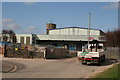
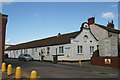
Cleethorpes fire station
Cleethorpes fire station, Poplar Road, Cleethorpes, Humberside
Image: © Kevin Hale
Taken: 4 Aug 2010
0.12 miles
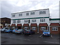
8
Across the rails: Lacey's restaurant in North Promenade
Image: © Chris
Taken: 21 Mar 2014
0.14 miles
9

The Flying Scotsman leaving Cleethorpes railway station #1
Image: © Steve Fareham
Taken: 11 Jun 2016
0.14 miles