IMAGES TAKEN NEAR TO
Lombard Street, GRIMSBY, DN34 4BJ
Introduction
This page details the photographs taken nearby to Lombard Street, DN34 4BJ by members of the Geograph project.
The Geograph project started in 2005 with the aim of publishing, organising and preserving representative images for every square kilometre of Great Britain, Ireland and the Isle of Man.

There are currently over 7.5m images from over14,400 individuals and you can help contribute to the project by visiting https://www.geograph.org.uk
Image Map (Loading...)


Getting Data...Please wait
Leaflet Map data © OpenStreetMap
Images are licensed for reuse under creativecommons.org/licenses/by-sa/2.0
Notes
- Clicking on the map will re-center to the selected point.
- The higher the marker number, the further away the image location is from the centre of the postcode.
Image Listing (11 Images Found)
Images are licensed for reuse under creativecommons.org/licenses/by-sa/2.0
Image
Details
Distance
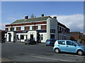
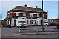
2
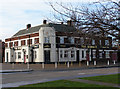
Yarborough Road, Grimsby
The Market Public House. (Formerly The Market Hotel) A Locally Listed Building.
http://flickr.com/photos/riffraff1/2075135491/
Image: © David Hebb
Taken: 22 Jan 2009
0.14 miles
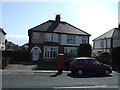
4
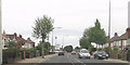
Yarborough Road approaching Cromwell Road roundabout
Image: © John Firth
Taken: 10 Jun 2013
0.16 miles
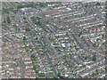
5
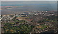
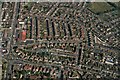
Grimsby, across the Yarborough Estate, to Spurn Point: aerial 2015
Image: © Chris
Taken: 9 Aug 2015
0.16 miles
7
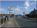
Yarborough Road (A1136)
Approaching roundabout.
Image: © JThomas
Taken: 30 Mar 2013
0.16 miles
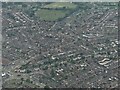
9
Yarborough district of Grimsby: aerial 2021 (2)
Image: © Simon Tomson
Taken: 5 Jun 2021
0.17 miles