IMAGES TAKEN NEAR TO
Ravenfield Road, DONCASTER, DN3 3JY
Introduction
This page details the photographs taken nearby to Ravenfield Road, DN3 3JY by members of the Geograph project.
The Geograph project started in 2005 with the aim of publishing, organising and preserving representative images for every square kilometre of Great Britain, Ireland and the Isle of Man.

There are currently over 7.5m images from over14,400 individuals and you can help contribute to the project by visiting https://www.geograph.org.uk
Image Map (8 Images)


Getting Data...Please wait
Leaflet Map data © OpenStreetMap
Images are licensed for reuse under creativecommons.org/licenses/by-sa/2.0
Notes
- Clicking on the map will re-center to the selected point.
- The higher the marker number, the further away the image location is from the centre of the postcode.
Image Listing (8 Images Found)
Images are licensed for reuse under creativecommons.org/licenses/by-sa/2.0
Image
Details
Distance
1
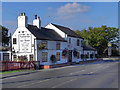
Horse and Groom
The Horse and Groom, nutwell Lane, Armthorpe
Image: © David Dixon
Taken: 14 Oct 2011
0.05 miles
2
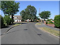
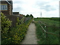
Remember when all this was Fields?
With Raven Field Road to the left and East Field Road to the right those that can remember when this part of Armthorpe was all fields can have a reminder of their names.
Image: © Michael Patterson
Taken: 24 Jul 2006
0.07 miles
4
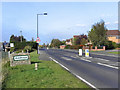
Nutwell Lane, Armthorpe
Entering Armthorpe village via Nutwell Lane.
Image: © David Dixon
Taken: 14 Oct 2011
0.18 miles
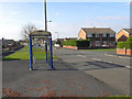
6
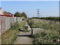
Path Behind Fiddlers Drive
The path runs, from Nutwell Lane, alongside the modern housing estate, towards the M18 motorway.
Image: © David Dixon
Taken: 14 Oct 2011
0.20 miles
7
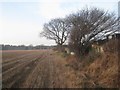
Stubble field behind the houses in Ladycroft Road
Image: © Jonathan Thacker
Taken: 11 Jan 2013
0.22 miles
8
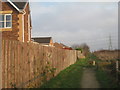
Footpath to Branton
Off Nutwell Lane.
Image: © Jonathan Thacker
Taken: 11 Jan 2013
0.23 miles