IMAGES TAKEN NEAR TO
Rands Lane Industrial Estate, DONCASTER, DN3 3EW
Introduction
This page details the photographs taken nearby to Rands Lane Industrial Estate, DN3 3EW by members of the Geograph project.
The Geograph project started in 2005 with the aim of publishing, organising and preserving representative images for every square kilometre of Great Britain, Ireland and the Isle of Man.

There are currently over 7.5m images from over14,400 individuals and you can help contribute to the project by visiting https://www.geograph.org.uk
Image Map (Loading...)


Getting Data...Please wait
Leaflet Map data © OpenStreetMap
Images are licensed for reuse under creativecommons.org/licenses/by-sa/2.0
Notes
- Clicking on the map will re-center to the selected point.
- The higher the marker number, the further away the image location is from the centre of the postcode.
Image Listing (10 Images Found)
Images are licensed for reuse under creativecommons.org/licenses/by-sa/2.0
Image
Details
Distance

2
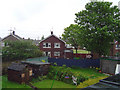
Armthorpe
Typical housing in Armthorpe, Doncaster.
Image: © Scott Robinson
Taken: 20 May 2006
0.12 miles
3
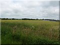
Field on the Fringes of Armthorpe
The Lings near the north eastern edge of the village.
Image: © Jonathan Clitheroe
Taken: 30 May 2016
0.17 miles
4
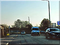
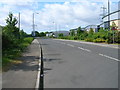
Durham Lane, Armthorpe Industrial Estate
Image: © David Dixon
Taken: 14 Oct 2011
0.18 miles
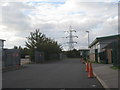

10
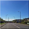
Factory units, West Moors Park
Part of a standard but not unattractive design.
Image: © Jonathan Thacker
Taken: 26 Sep 2012
0.25 miles