IMAGES TAKEN NEAR TO
Scartho Road, GRIMSBY, DN33 2BP
Introduction
This page details the photographs taken nearby to Scartho Road, DN33 2BP by members of the Geograph project.
The Geograph project started in 2005 with the aim of publishing, organising and preserving representative images for every square kilometre of Great Britain, Ireland and the Isle of Man.

There are currently over 7.5m images from over14,400 individuals and you can help contribute to the project by visiting https://www.geograph.org.uk
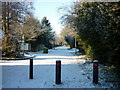
Image Map
Images are licensed for reuse under creativecommons.org/licenses/by-sa/2.0
Notes
- Clicking on the map will re-center to the selected point.
- The higher the marker number, the further away the image location is from the centre of the postcode.
Image Listing (12 Images Found)
Images are licensed for reuse under creativecommons.org/licenses/by-sa/2.0
Image
Details
Distance
1
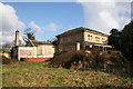
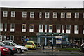
Scartho Hall
Derelict, vandalised and awaiting re-development
Image: © Richard Croft
Taken: 20 Feb 2006
0.08 miles
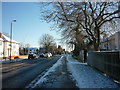
5
Wet afternoon in May at the Diana, Princess of Wales Hospital
Only 4.30 pm but looking much later in the rain.
Image: © Chris
Taken: 27 May 2014
0.19 miles
6
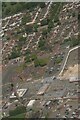
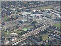
Grimsby hospital and former Workhouse: aerial 2021 (1)
Image: © Chris
Taken: 5 Jun 2021
0.19 miles
7
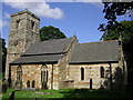
St.Giles' church, Scartho, Lincs.
Anglo-Saxon W tower with 19th & 20th century embellishments
Image: © Richard Croft
Taken: 25 Aug 2005
0.20 miles
9
Grimsby hospital, former Workhouse and Nunsthorpe: aerial 2022
Image: © Simon Tomson
Taken: 6 Mar 2022
0.24 miles
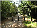
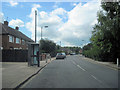
10
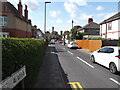
Beech Avenue, Scartho
The chimney and tower are in the hospital grounds
Image: © David Brown
Taken: 23 Aug 2024
0.24 miles