IMAGES TAKEN NEAR TO
Scartho Road, GRIMSBY, DN33 2AB
Introduction
This page details the photographs taken nearby to Scartho Road, DN33 2AB by members of the Geograph project.
The Geograph project started in 2005 with the aim of publishing, organising and preserving representative images for every square kilometre of Great Britain, Ireland and the Isle of Man.

There are currently over 7.5m images from over14,400 individuals and you can help contribute to the project by visiting https://www.geograph.org.uk
Image Map
Images are licensed for reuse under creativecommons.org/licenses/by-sa/2.0
Notes
- Clicking on the map will re-center to the selected point.
- The higher the marker number, the further away the image location is from the centre of the postcode.
Image Listing (10 Images Found)
Images are licensed for reuse under creativecommons.org/licenses/by-sa/2.0
Image
Details
Distance
4
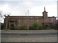
St Martin's church, Grimsby
Designed by Lawrence Bond in 1938
Image: © Jonathan Thacker
Taken: 23 Apr 2012
0.13 miles
5
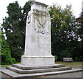
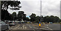
Grimsby Cenotaph
The Grimsby Cenotaph is situated at Nun’s Corner, Grimsby, an elongated roundabout at the junction of the A46 (Weelsby Road) and the B1203 (Bargate), close to the junction with Eastwood Avenue. Parking may be had along Eastwood Avenue, which is a cul de sac. The memorial is set on a triangular site, at the junction of the roundabout and Eastwood Avenue. A pavement goes straight past the memorial on 2 sides of the site. The site consists of the main structure on its base, rose garden beds, lawns and trees. The site is permanently illuminated, day and night.It is constructed from white Carrara marble especially brought from Italy. The cenotaph stands on a base of grey granite steps, three in all, measuring 6720mm x 5760mm at their widest point. The cenotaph itself measures 6000mm high, and is 2760mm x 1840mm at its base. On December 18th, 1921, the Cenotaph was unveiled by the Mayor of Grimsby, Ald. Frank Thornton.
Image: © John Readman
Taken: 16 May 2003
0.14 miles
6
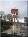
Welcome to Nunsthorpe
The Nunsthorpe estate hasn't always received the best press in Grimsby but in recent years a lot of money has been spent in the area including on this entrance sign.
Image: © Jonathan Thacker
Taken: 23 Apr 2012
0.16 miles
8
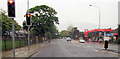
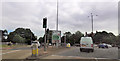
Sutcliffe Avenue junction with Scartho Road
Image: © John Firth
Taken: 16 Jun 2012
0.19 miles
9
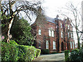
Bargate, Grimsby
Fryston House, situated at "Fryston Corner" was built in the 1870's for local Corn Merchant Robert Norfolk. it was then called "Southfield House" In 1897 it was bought by the Bennetts who were Timber Importers in whose hands it remained until being bought by the local Council for conversion to a home for elderly men in the early 1950's (Fryston House is a Locally Listed Building) http://www.flickr.com/photos/riffraff1/2227895253/
Image: © David Hebb
Taken: 2 Oct 2008
0.20 miles