IMAGES TAKEN NEAR TO
Holmshaw Close, DONCASTER, DN3 2TQ
Introduction
This page details the photographs taken nearby to Holmshaw Close, DN3 2TQ by members of the Geograph project.
The Geograph project started in 2005 with the aim of publishing, organising and preserving representative images for every square kilometre of Great Britain, Ireland and the Isle of Man.

There are currently over 7.5m images from over14,400 individuals and you can help contribute to the project by visiting https://www.geograph.org.uk
Image Map (Loading...)


Getting Data...Please wait
Leaflet Map data © OpenStreetMap
Images are licensed for reuse under creativecommons.org/licenses/by-sa/2.0
Notes
- Clicking on the map will re-center to the selected point.
- The higher the marker number, the further away the image location is from the centre of the postcode.
Image Listing (14 Images Found)
Images are licensed for reuse under creativecommons.org/licenses/by-sa/2.0
Image
Details
Distance
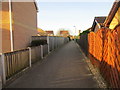
1
Small green space off Eden Field Road
Image: © Jonathan Thacker
Taken: 14 Mar 2017
0.05 miles
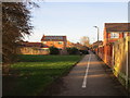
2
Footpath behind Eden Field Road
Pre-existed the housing development.
Image: © Jonathan Thacker
Taken: 14 Mar 2017
0.07 miles
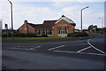
3

Eden Arms on Eden Field Road, Edenthorpe
http://www.geograph.org.uk/photo/5689832
Image: © Ian S
Taken: 22 Feb 2018
0.15 miles
4
Eden Arms on Eden Field Road, Edenthorpe
http://www.geograph.org.uk/photo/5689833
Image: © Ian S
Taken: 22 Feb 2018
0.15 miles
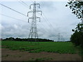
6
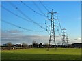
Electricity pylons
Marching across fields to the east of Kirk Sandall.
Image: © Graham Hogg
Taken: 20 Jan 2023
0.16 miles
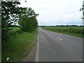
7
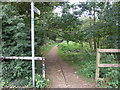
Path Through the Woods
This footpath passes through more trees than it did on the 1940s OS map, a few more houses too.
Image: © Michael Patterson
Taken: 16 Oct 2006
0.17 miles
9
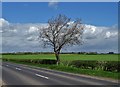
Lone tree by Kirk Sandall Common
Seen from Armthorpe Lane
Image: © Neil Theasby
Taken: 26 Apr 2018
0.19 miles