IMAGES TAKEN NEAR TO
Mere Lane, DONCASTER, DN3 2DF
Introduction
This page details the photographs taken nearby to Mere Lane, DN3 2DF by members of the Geograph project.
The Geograph project started in 2005 with the aim of publishing, organising and preserving representative images for every square kilometre of Great Britain, Ireland and the Isle of Man.

There are currently over 7.5m images from over14,400 individuals and you can help contribute to the project by visiting https://www.geograph.org.uk
Image Map (Loading...)


Getting Data...Please wait
Leaflet Map data © OpenStreetMap
Images are licensed for reuse under creativecommons.org/licenses/by-sa/2.0
Notes
- Clicking on the map will re-center to the selected point.
- The higher the marker number, the further away the image location is from the centre of the postcode.
Image Listing (8 Images Found)
Images are licensed for reuse under creativecommons.org/licenses/by-sa/2.0
Image
Details
Distance
2

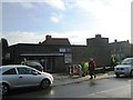
Church of Our Lady of Sorrows and St Francis
Opened in 1959 to serve the growing population in Armthorpe
Image: © Graham Hogg
Taken: 27 Mar 2023
0.13 miles
3
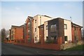
Apartment blocks, Mere Lane, Armthorpe
Image: © Jonathan Thacker
Taken: 11 Jan 2013
0.15 miles