IMAGES TAKEN NEAR TO
Doncaster Road, DONCASTER, DN3 2BT
Introduction
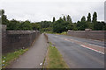
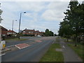
This page details the photographs taken nearby to Doncaster Road, DN3 2BT by members of the Geograph project.
The Geograph project started in 2005 with the aim of publishing, organising and preserving representative images for every square kilometre of Great Britain, Ireland and the Isle of Man.

There are currently over 7.5m images from over14,400 individuals and you can help contribute to the project by visiting https://www.geograph.org.uk
Image Map (Loading...)


Getting Data...Please wait
Leaflet Map data © OpenStreetMap
Images are licensed for reuse under creativecommons.org/licenses/by-sa/2.0
Notes
- Clicking on the map will re-center to the selected point.
- The higher the marker number, the further away the image location is from the centre of the postcode.
Image Listing (13 Images Found)
Images are licensed for reuse under creativecommons.org/licenses/by-sa/2.0
Image
Details
Distance
1

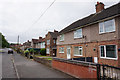
New housing, Paxton Crescent, Armthorpe
On the site of the former Methodist church which closed in 2007.
Image: © Jonathan Thacker
Taken: 11 Jan 2013
0.12 miles
3
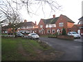
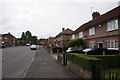
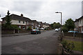
Housing, Doncaster Road, Armthorpe
Some of the housing on Doncaster Road is set-back to give some variety, though the houses themselves are the same as their neighbours.
Image: © Jonathan Thacker
Taken: 11 Jan 2013
0.14 miles