IMAGES TAKEN NEAR TO
Hainton Avenue, GRIMSBY, DN32 9QN
Introduction
This page details the photographs taken nearby to Hainton Avenue, DN32 9QN by members of the Geograph project.
The Geograph project started in 2005 with the aim of publishing, organising and preserving representative images for every square kilometre of Great Britain, Ireland and the Isle of Man.

There are currently over 7.5m images from over14,400 individuals and you can help contribute to the project by visiting https://www.geograph.org.uk
Image Map
Images are licensed for reuse under creativecommons.org/licenses/by-sa/2.0
Notes
- Clicking on the map will re-center to the selected point.
- The higher the marker number, the further away the image location is from the centre of the postcode.
Image Listing (49 Images Found)
Images are licensed for reuse under creativecommons.org/licenses/by-sa/2.0
Image
Details
Distance
1
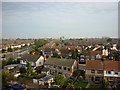
Looking North
Taken from Peaks Lane Fire Station Tower.
Image: © Ian S
Taken: 22 Sep 2010
0.06 miles
3
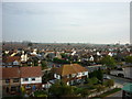
Looking North East
Taken from Peaks Lane Fire Station Tower.
Image: © Ian S
Taken: 22 Sep 2010
0.11 miles
5
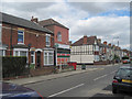
Shop and Houses in Heneage road
The shop used to be the Co-op and is on the corner of Heneage Road and Torrington Street
Image: © John Firth
Taken: 5 Jul 2010
0.12 miles
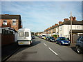
6
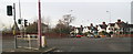
Crossing Peaks Parkway from the east, along Weelsby Road
Image: © Chris
Taken: 18 Dec 2013
0.13 miles
7
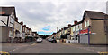
Heneage Road at David Street
The 2 shops on the left used to be a butcher and a Chip shop. The house on the left hand corner used to be Horns the baker
Image: © John Firth
Taken: 8 Jul 2015
0.13 miles
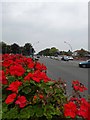
8
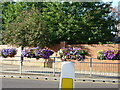
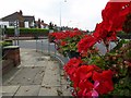
Flowers at crossroads
At the Peaks Parksway and Weelsby Road junction, Grimsby.
Image: © Ian S
Taken: 18 Aug 2010
0.13 miles
10
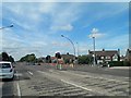
Peaks Parkway traffic lights, Grimsby
Image: © Steve Fareham
Taken: 30 Jun 2013
0.14 miles