IMAGES TAKEN NEAR TO
Hainton Avenue, GRIMSBY, DN32 9LU
Introduction
This page details the photographs taken nearby to Hainton Avenue, DN32 9LU by members of the Geograph project.
The Geograph project started in 2005 with the aim of publishing, organising and preserving representative images for every square kilometre of Great Britain, Ireland and the Isle of Man.

There are currently over 7.5m images from over14,400 individuals and you can help contribute to the project by visiting https://www.geograph.org.uk
Image Map (Loading...)


Getting Data...Please wait
Leaflet Map data © OpenStreetMap
Images are licensed for reuse under creativecommons.org/licenses/by-sa/2.0
Notes
- Clicking on the map will re-center to the selected point.
- The higher the marker number, the further away the image location is from the centre of the postcode.
Image Listing (45 Images Found)
Images are licensed for reuse under creativecommons.org/licenses/by-sa/2.0
Image
Details
Distance
1

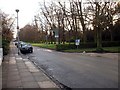
Park Drive, Grimsby
Fine Edwardian houses on the East side of Park Drive fronting to People's Park.
Image: © David Wright
Taken: 10 Jan 2003
0.10 miles
2
People's Park, Grimsby
View looking along east side of Park Drive with People's Park on the right
Image: © David Wright
Taken: 10 Jan 2003
0.10 miles
3
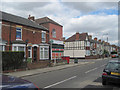
Shop and Houses in Heneage road
The shop used to be the Co-op and is on the corner of Heneage Road and Torrington Street
Image: © John Firth
Taken: 5 Jul 2010
0.10 miles
4
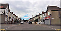
Heneage Road at David Street
The 2 shops on the left used to be a butcher and a Chip shop. The house on the left hand corner used to be Horns the baker
Image: © John Firth
Taken: 8 Jul 2015
0.10 miles
5
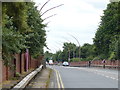
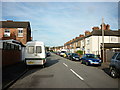
Heading south along the A16 in Grimsby
Image: © Mat Fascione
Taken: 24 Jul 2016
0.11 miles
7
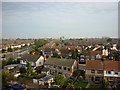
Looking North
Taken from Peaks Lane Fire Station Tower.
Image: © Ian S
Taken: 22 Sep 2010
0.13 miles
8
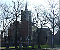
Welholme Road, Grimsby
The former Welholme Road Congregational Church, built in 1907 by Hewins and Goodhand of Grimsby. Also incorporating the 1894 Congregational mission Church and Sunday School. ( both are Grade II Listed Buildings)
http://flickr.com/photos/riffraff1/3033739273/
Image: © David Hebb
Taken: 27 Jan 2009
0.14 miles
9
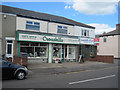
Crosskill The Florist on Heneage Road
This shop lies on the corner of Heneage Road and Granville Street. Part of the shop has been in existence as Crosskills for more than 60 years. The left hand side used to be Mogers the Newsagents
Image: © John Firth
Taken: 5 Jul 2010
0.15 miles
10
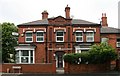
Shakespeare House
Currently used as a dental surgery, Shakespeare House stands at the corner of Welholme Road and Hainton Avenue.
Image: © David Rogers
Taken: 30 May 2008
0.15 miles