IMAGES TAKEN NEAR TO
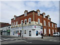
Tivoli Gardens, GRIMSBY, DN32 7SE
Introduction
This page details the photographs taken nearby to Tivoli Gardens, DN32 7SE by members of the Geograph project.
The Geograph project started in 2005 with the aim of publishing, organising and preserving representative images for every square kilometre of Great Britain, Ireland and the Isle of Man.

There are currently over 7.5m images from over14,400 individuals and you can help contribute to the project by visiting https://www.geograph.org.uk
Image Map
Images are licensed for reuse under creativecommons.org/licenses/by-sa/2.0
Notes
- Clicking on the map will re-center to the selected point.
- The higher the marker number, the further away the image location is from the centre of the postcode.
Image Listing (121 Images Found)
Images are licensed for reuse under creativecommons.org/licenses/by-sa/2.0
Image
Details
Distance
1
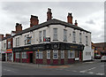
The Angel, Freeman Street, Grimsby
The Angel stands on the corner of Freeman Street and Wood Street.
Image: © David Wright
Taken: 29 Apr 2010
0.03 miles
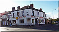
2
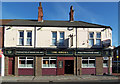
The Angel Hotel
The Angel Hotel, Freeman Street.
Image: © David Wright
Taken: 21 Oct 2006
0.03 miles
3
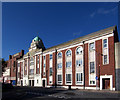
Methodist Central Hall
Methodist Central Hall, Duncombe Street. Pevsner says "METHODIST CENTRAL HALL,Duncombe Street. 1934 by A. Brocklehurst of Manchester. Brick and stone dressings with vertical bands of windows. A copper dome over the entrance bay."
Image: © David Wright
Taken: 21 Oct 2006
0.04 miles
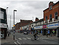
4
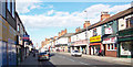
Freeman Street
Photo taken from Wellington Street looking towards the Dock Tower.
Image: © David Wright
Taken: 21 Oct 2006
0.04 miles
5
The Warehouse, Freeman Street
Freeman Street was once a thriving shopping area serving principally the fishing community, But like fishing itself Freeman Street has declined. The Warehouse is just one attempt to bring life back to the street. http://www.thewarehousegy.co.uk/
Image: © Jonathan Thacker
Taken: 27 May 2016
0.04 miles
6
The Wellington Arms
Grimsby Town Football Club was formed in 1878 after a meeting held at the Wellington Arms public house in Freeman Street. The club was originally called Grimsby Pelham, this being the family name of the Earl of Yarborough, a significant landowner in the area. The name was changed the following year to Grimsby Town. In 1880 the club purchased land at Clee Park which was to become their ground until 1889 when they relocated to Abbey Park, before moving again in 1899 to their present home, Blundell Park Image
Image: © David Wright
Taken: 21 Oct 2006
0.05 miles
8
Freeman Street, Grimsby
Photo taken from the corner of Newmarket Street.
Image: © David Wright
Taken: 29 Apr 2010
0.06 miles
9
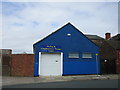
Healing and Complementary Therapy Centre
Image: © Jonathan Thacker
Taken: 27 May 2016
0.06 miles
10
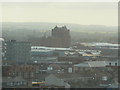
Victoria Mills and beyond from Ross House
Image: © Chris Barker
Taken: 27 Apr 2007
0.07 miles