
IMAGES TAKEN NEAR TO
Wellington Street, GRIMSBY, DN32 7EA
Introduction
This page details the photographs taken nearby to Wellington Street, DN32 7EA by members of the Geograph project.
The Geograph project started in 2005 with the aim of publishing, organising and preserving representative images for every square kilometre of Great Britain, Ireland and the Isle of Man.

There are currently over 7.5m images from over14,400 individuals and you can help contribute to the project by visiting https://www.geograph.org.uk
Image Map
Images are licensed for reuse under creativecommons.org/licenses/by-sa/2.0
Notes
- Clicking on the map will re-center to the selected point.
- The higher the marker number, the further away the image location is from the centre of the postcode.
Image Listing (102 Images Found)
Images are licensed for reuse under creativecommons.org/licenses/by-sa/2.0
Image
Details
Distance
1
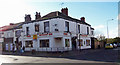
The Wellington Arms
Grimsby Town Football Club was formed in 1878 after a meeting held at the Wellington Arms public house in Freeman Street. The club was originally called Grimsby Pelham, this being the family name of the Earl of Yarborough, a significant landowner in the area. The name was changed the following year to Grimsby Town. In 1880 the club purchased land at Clee Park which was to become their ground until 1889 when they relocated to Abbey Park, before moving again in 1899 to their present home, Blundell Park Image
Image: © David Wright
Taken: 21 Oct 2006
0.04 miles
2
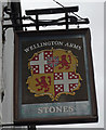
The Sign of the Wellington Arms
The Wellington Arms is situated on Freeman Street Image
Image: © David Wright
Taken: 29 Apr 2010
0.04 miles
3
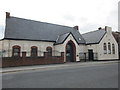
e-factor, grimsby
A business enterprise centre.
Image: © Jonathan Thacker
Taken: 27 May 2016
0.04 miles
4
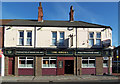
The Angel Hotel
The Angel Hotel, Freeman Street.
Image: © David Wright
Taken: 21 Oct 2006
0.06 miles
5
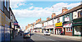
Freeman Street
Photo taken from Wellington Street looking towards the Dock Tower.
Image: © David Wright
Taken: 21 Oct 2006
0.06 miles
7
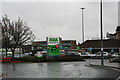
Back of Asda's, from Railway Street
February, and the wettest weather for over. Somerset Levels have been under water for two months and the Thames has burst its banks.
Wales has experienced gusts of 108 mph. The bad weather is said to result from the jagged shape of the jetstream.
All doom and gloom, making the lights of Asda's petrol station look almost welcoming.
See also Image
Image: © Chris
Taken: 14 Feb 2014
0.06 miles
8
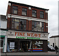
Fine Weave, Freeman Street, Grimsby
Behind the modern fascia a rather good late Victorian or Edwardian shop apparently retaining the original fenestration.
Image: © David Wright
Taken: 29 Apr 2010
0.07 miles
9
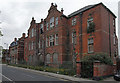
Derelict Art School, Eleanor Road, Grimsby
A solid Victorian building which has been allowed to fall into state of dereliction.
Image: © David Wright
Taken: 29 Apr 2010
0.08 miles
10
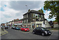
Freeman Street, Grimsby
Photo taken at the junction with Ellis Way.
Image: © David Wright
Taken: 14 May 2010
0.08 miles