IMAGES TAKEN NEAR TO
Doughty Road, GRIMSBY, DN32 0LP
Introduction
This page details the photographs taken nearby to Doughty Road, DN32 0LP by members of the Geograph project.
The Geograph project started in 2005 with the aim of publishing, organising and preserving representative images for every square kilometre of Great Britain, Ireland and the Isle of Man.

There are currently over 7.5m images from over14,400 individuals and you can help contribute to the project by visiting https://www.geograph.org.uk
Image Map
Images are licensed for reuse under creativecommons.org/licenses/by-sa/2.0
Notes
- Clicking on the map will re-center to the selected point.
- The higher the marker number, the further away the image location is from the centre of the postcode.
Image Listing (221 Images Found)
Images are licensed for reuse under creativecommons.org/licenses/by-sa/2.0
Image
Details
Distance
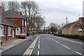
1
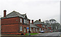
Provident Homes, Doughty Road
Erected in 1897 for Queen Victoria's Diamond Jubilee.
Image: © David Wright
Taken: 23 Apr 2008
0.03 miles
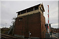
3
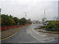
NE Lincs. Council Depot
Doughty Road council depot.
Image: © David Wright
Taken: 23 Apr 2008
0.04 miles
4
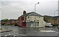
Vacant Shops on Garden Street.
Photo taken at the junction of Garden Street and Doughty Road.
Image: © David Wright
Taken: 23 Apr 2008
0.07 miles
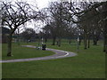
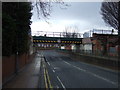
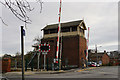
6
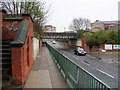
Doughty Road
At this point Doughty Road runs in a cutting to carry it below the railway. Clearance is only 11' 3".
Image: © David Wright
Taken: 23 Apr 2008
0.08 miles